The lakes that form on Antarctica’s ice shelves can drive vertical cracks deep within the ice, increasing the chance of ice shelf collapse and sea level rise. However, if meltwater accumulates in certain areas and drains fast enough, it may temporarily stabilize the ice shelf despite increased warming, according to researchers.
“Antarctica’s ice is the largest potential source of sea level rise,” said Luke Trusel, assistant professor of geography at Penn State. “A significant percentage of the global population lives along the coastline in many of the world’s largest cities. We need to understand what is happening to ice shelves to make reliable sea level predictions. Water can destabilize ice shelves, so we need to know where the water is and what it’s doing.”
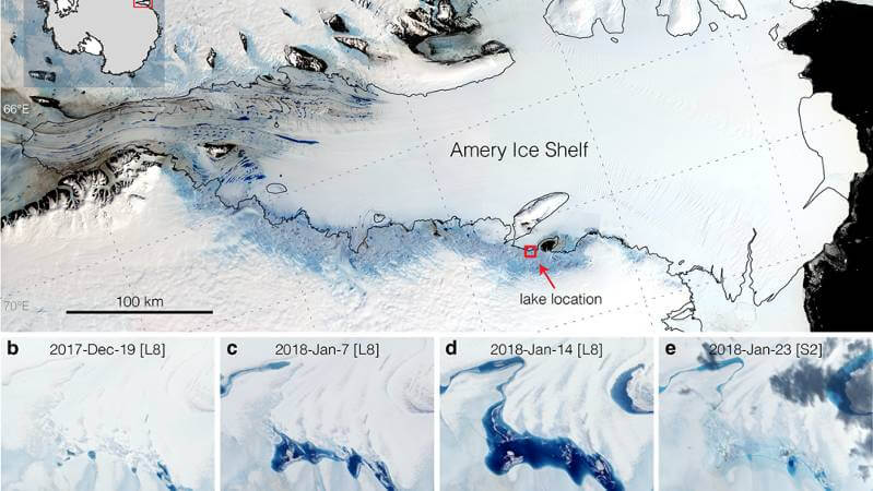
Trusel and his colleagues used satellite data to study a meltwater lake that forms annually at the grounding line of the Amery Ice Shelf in East Antarctica. The grounding line is a zone where land ice transitions to a floating ice shelf that prevents the land ice from flowing into the ocean and raising sea levels. The ice in this area tends to dip and form a basin that could collect water.
The researchers found that strong tidal activity may facilitate water-induced fracturing, or hydrofracturing, at the grounding line and cause the meltwater lake to drain quickly, often in as little as several days. The rapid draining prevents more water from accumulating and spreading onto the ice shelf, where hydrofracturing would raise the potential for collapse. The team reported their findings, which are the first observations of tides potentially forcing large-scale lake drainage, in Geophysical Research Letters.
The researchers used data from the Landsat 8 and Sentinel-1 satellites to measure and track changes to the lake during the austral summers — December through February — of 2014 to 2020. Whereas an ordinary camera captures three different wavelengths — red, green and blue — to create an image, the Landsat 8 instruments can capture up to 11 spectral bands, including infrared light. The data return as pixels that can be used to map ice, water, snow and cloud cover.
Zhuolai Pan, a master’s student in geography at Penn State who started on the project as an undergraduate, used the Landsat images to calculate lake volume and create a time series that shows the lake forming and draining. To refine the time series, the team used data from the radar imaging sensors on twin Sentinel-1 satellites. The instruments have a resolution of approximately 33 feet and can see through cloud cover, which is important because Antarctica’s coasts can often see more clouds than sun.
The lake is approximately 2.3 square miles and 65 feet deep and contains almost 5 billion gallons of water, enough water to fill nearly 7,200 Olympic-sized swimming pools, according to the researchers.
“It’s not the biggest lake, but it’s appreciable in terms of its size,” Trusel said. “The more interesting aspect is the dynamics, how the water is changing so quickly and what that may mean for our understanding of ice shelf stability. A large volume of water is just disappearing, and it’s doing this almost every year.”
The researchers also examined high resolution satellite imagery taken after a drainage event. The images showed the lake bottom, where the team found a 26-foot-deep and 800-foot-wide crater, ice blocks that would have fit inside the crater and a more than 2,100-foot-long fracture. These details indicate that the water most likely drained vertically, roughly 2,000 feet through the ice.
“This is the most detailed view of a freshly drained lake in Antarctica we’ve ever had,” said Trusel, noting that the features they spotted had only previously been observed on the much warmer and wetter Greenland Ice Sheet.
Drainage events occurred at least once a year for all years with sufficient observations and at different lake volumes. Given that drainage seemed to occur at different lake volumes and depths, as well as around the new and full moon, the researchers think that strong tidal activity, instead of water volume, was the driving force.
Earth experiences stronger tidal activity when the Earth, moon and sun align, Trusel said. Because they float in the ocean, ice shelves are subject to tidal activity. Higher high tides force the ice shelf to flex up and generate stresses at the base of the ice that could cause a fracture. Lower low tides force the ice shelf to flex downward, transferring those stresses to the surface of the ice and potentially extending the fracture. The weight of the water at the surface could cause the fracture to propagate through the ice shelf until an opening forms and drains the lake.
“The tides flex the ice shelf at the grounding line,” said Trusel. “The ice is acting like a door hinge, with stresses occurring at the top and bottom of the ice right where this lake exists.”
Scientists have thought that water at the surface is a precursor for ice shelf collapse. They observed the phenomenon when the Larsen B Ice Shelf collapsed in 2002. Earlier Landsat data, however, shows the lake in the current study forming as far back as the 1970s, said Pan. Many of the same lakes that dot the ice shelf today also appear in aerial photographs taken by the U.S. Navy shortly after World War II.
“Revisiting observations from older aerial imagery and satellite data, we see that much of this water has been around for some time, and so there’s more nuance here,” Trusel said. “Water and ice can in some instances coexist. There’s more we need to know about how exactly it impacts ice shelf stability.”
The scientists’ next step is to investigate whether other lakes in the region drain as a result of tidal activity. The current study raises many questions, Trusel said, but it represents the latest step to better understanding ice shelf stability and how fast seas will rise in the future.
Mahsa Moussavi, a formal postdoctoral researcher at the National Snow and Ice Data Center and now at General Motors, also contributed to the study. The National Science Foundation and Penn State supported this research.