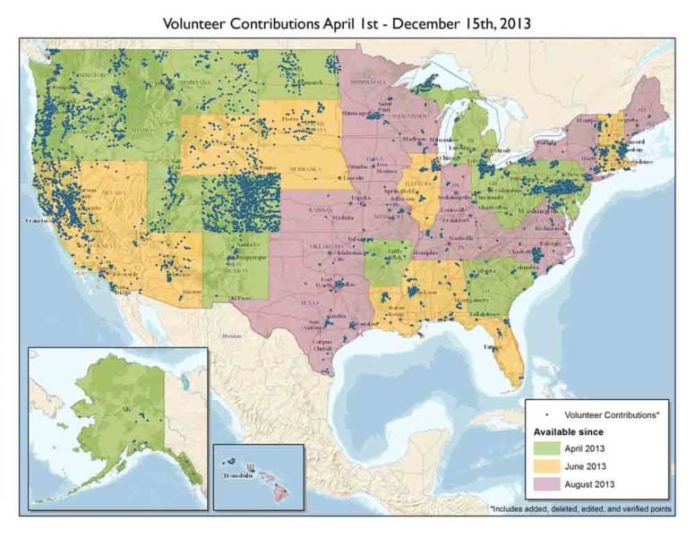
Civilian volunteers are making significant additions to the U.S. Geological Survey’s ability to provide accurate mapping information to the public. Using crowd-sourcing techniques, the USGS’ Volunteered Geographic Information (VGI) project known as The National Map Corps(TNMCorps) encourages citizen volunteers to collect manmade structures data in an effort to provide accurate and authoritative spatial map data for the National Geospatial Program’s web-based The National Map.
Structures being updated include schools, hospitals, post offices, police stations and other important public buildings.
Starting as a series of pilot projects in 2011, nearly 400 volunteers edited structures in the state of Colorado and contributed more than 6,800 edits. With approval to expand the project, the USGS began releasing the rest of the United States for editing in a phased approach in April 2013. By August of this year, volunteers were editing in every state in the country. To date, the numbers of volunteers has more than tripled, and the number of submitted edits has exceeded 25,000.
 “The number of points contributed and edited by volunteers is incredible,” said Kari Craun, the director of the National Geospatial Technical Operations Center. “Our challenge going forward will be to keep volunteers motivated and to make sure we have coverage in all areas of the United States. We think at least part of that motivation will come from letting volunteers — and potential volunteers — know how valuable the information they contribute is to the USGS and to the users of the data. So to all of those who have contributed, thank you for your time and energy!
To show appreciation of the volunteers’ efforts, The National Map Corps has instituted a recognition programthat awards “virtual” badges to volunteers. Each edit that is submitted is worth one point towards the badge level. The badges consist of a series of antique surveying instruments ranging from the Order of the Surveyor’s Chain (25 – 50 points) to the Theodolite Assemblage (2000+ points). Additionally, volunteers are publically acknowledged (with permission) via Twitter, Facebook and Google+.
Tools on TNMCorps web site explain how a volunteer can edit any area, regardless of their familiarity with the selected structures, and becoming a volunteer for TNMCorps is easy; go to The National Map Corps web site to learn more and to sign up as a volunteer. If you have access to the Internet and are willing to dedicate some time to editing map data, we hope you will consider participating.


