The magnitude 6 earthquake that shook the Napa Valley in August was the strongest the region had felt in more than 20 years. But the next earthquake in the area could be much stronger, according to preliminary research from the University of California, Davis, presented this week at the American Geophysical Union conference in San Francisco.
New technologies and social media enabled the UC Davis team to produce scientific information for the public at unprecedented speeds following the quake.
“Much more devastating”
The team of geologists and graduate students from the UC Davis Department of Earth and Planetary Sciences found that the West Napa Fault line is longer than previously thought, and capable of a much stronger, more destructive earthquake in the future.
The researchers found that the total fault length is about 45 miles. That is enough to produce a magnitude 7 earthquake, which has 31 times the energy release of a magnitude 6 earthquake. That energy release happens on a longer section of fault with more slippage, which contributes to producing bigger earthquakes.
“In terms of Napa Valley, it raises what is possible,” said associate professor Mike Oskin, who helped lead a class in measuring and mapping the fault. “It would be a much larger earthquake and much more devastating than what has happened historically.”
While the scientists do not predict when such a quake might occur, geological evidence along the fault suggests it might happen every 1,000 to 2,000 years, though Oskin said no one knows precisely.
The class also compared this year’s earthquake to one that occurred in nearby Yountville in 2000 and found they were on the same fault, affirming that a small portion of fault ruptured twice in the past 15 years.
Tweeting an earthquake
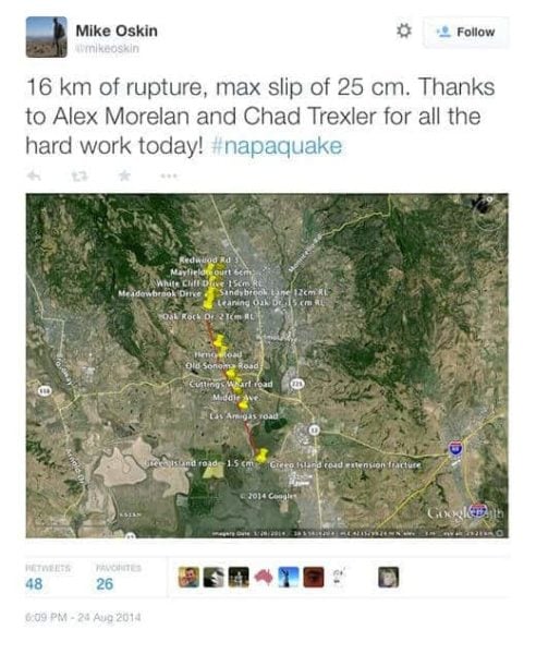
UC Davis graduate students Chad Trexler and Alex Morelan drove to Napa in the hours immediately following the earthquake. In a separate mapping project presented at the AGU meeting this week, Trexler described how they used smartphones, text messages, Twitter and Google Earth to create the first publicly available, online map of where the fault broke to the surface.
California has not experienced a surface-rupturing earthquake in more than 20 years, before such technologies were available.
“Twenty years is not long geologically speaking, but in terms of technology, it’s huge,” said Trexler. “Everyone wants to know where the fault broke for things like infrastructure repair and emergency response. The quicker you can get that up, the better.”
While they took traditional measurements in the field, they also snapped quick photos with a digital single-lens reflex, or DSLR, camera to document broken sidewalks, roads and curbs. Such things would soon be repaired and therefore missed by scientists attempting to measure them later. They could measure what the photos showed using 3-D modeling with software developed at the UC Davis W.M. Keck Center for Active Visualization in the Earth Sciences, or KeckCAVES.
As they worked, they sent text messages to Oskin, who posted much of what they were finding on Twitter. On Aug. 24 at 6:09 p.m. — 14 hours and 49 minutes after the quake began — Oskin tweeted, “16 km of rupture, max slip of 25 cm. Thanks to Alex Morelan and Chad Trexler for all the hard work today! #napaquake.” Below his post was an image of the students’ Google Earth layer showing a map of the rupture.
Their rapid response enabled other scientists and individuals to better evaluate and respond to the earthquake. Oskin said a lot of scientific evidence decays quickly during a disaster and is best used if gathered quickly.
“You can’t predict when disasters will happen,” he said. “But when they do, there are opportunities to learn something about how they work.”


