The European Space Agency successfully launched its Biomass satellite on April 29, marking a pivotal moment in forest monitoring that scientists are calling the dawn of the “forest space age.” The groundbreaking mission lifted off aboard a Vega-C rocket from Europe’s Spaceport in Kourou, French Guiana at 11:15 CEST, carrying technology that can essentially weigh Earth’s forests from space.
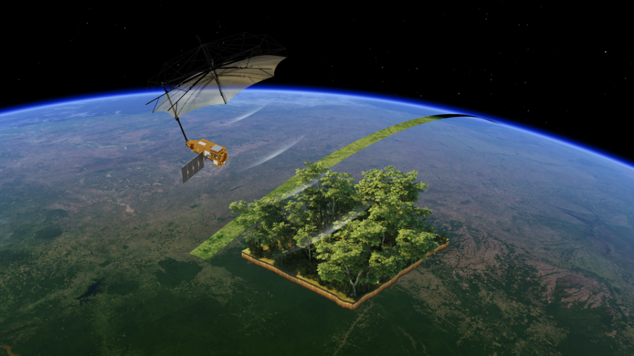
The satellite’s revolutionary P-band synthetic aperture radar can penetrate even the densest forest canopies to measure woody biomass – the trunks, branches, and stems where trees store most of their carbon. These measurements serve as a proxy for carbon storage, providing critical data that has eluded scientists until now.
Less than an hour after launch, mission controllers at ESA’s European Space Operations Centre in Germany received confirmation that Biomass had successfully separated from the rocket’s upper stage and was functioning as expected in orbit.
“Biomass now joins our esteemed family of Earth Explorers – missions that have consistently delivered groundbreaking discoveries and advanced scientific understanding of our planet,” said Simonetta Cheli, ESA’s Director of Earth Observation Programmes. “With Biomass, we are poised to gain vital new data on how much carbon is stored in the world’s forests, helping to fill key gaps in our knowledge of the carbon cycle and, ultimately, Earth’s climate system.”
The mission represents the culmination of a twenty-year journey for Lars Ulander, Professor of Radar Remote Sensing at Chalmers University of Technology, who was among the scientists who first proposed the satellite concept to ESA. “Our idea was to use a very special type of radar to map the world’s forests from space. The goal was to understand how forests affect the climate – and how climate change affects forests,” explained Ulander.
Forests absorb approximately 8 billion tonnes of carbon dioxide annually, functioning as Earth’s “green lungs” and helping regulate the planet’s temperature. However, deforestation and degradation, particularly in tropical regions, release stored carbon back into the atmosphere, accelerating climate change. Until now, scientists and policymakers have lacked accurate data on forest carbon storage and how these stocks change over time.
From its orbit 666 kilometers above Earth, Biomass will continuously produce global forest maps, addressing this critical data gap. It’s the first satellite equipped with a fully polarimetric P-band synthetic aperture radar for interferometric imaging – technology that uses radar wavelengths around 70 centimeters long to slice through forest canopies and measure the biomass beneath.
Controllers are now executing the complex “launch and early orbit” phase, which includes deploying the satellite’s massive 12-metre-wide mesh reflector supported by a 7.5-metre boom. Once operational, Biomass will join other space-based forest monitoring technologies, including NASA’s GEDI lidar system aboard the International Space Station and the upcoming US-India NISAR mission.
Despite these technological advances, experts emphasize that ground validation remains essential. “Even the most advanced satellite can’t tell a mahogany from a Brazil nut tree without help from the ground, and there are more than ten thousand tree species in the Amazon alone,” said Professor Oliver Phillips from the University of Leeds, who contributes to validation efforts.
To bridge this gap, researchers launched GEO-TREES, a global initiative uniting forestry, ecology, and remote-sensing experts. Klaus Scipal, ESA’s Biomass Mission Manager, explained, “The aim of GEO-TREES is to establish a sustainable funding mechanism to support ecologists and experts working in the forest to take the tree-by-tree measurements that are needed to validate satellite data products.”
This collaboration between space technology and ground-based science exemplifies the multidisciplinary approach needed to address climate change. “Satellites, such as our Biomass, offer a wealth of information to understand our changing world, but we must not forget those working tirelessly on the ground taking in situ measurements, often in difficult conditions, who allow us to have confidence in the data returned from space,” Scipal added.
The Biomass mission comes at a critical time, as accurate forest carbon data has become increasingly important for both climate science and policy. With more precise information, researchers can refine climate models and deepen understanding of the carbon cycle, ultimately informing more effective climate action strategies.
As Biomass begins its mission orbiting Earth every 98 minutes, it represents not just a technological achievement but a new chapter in humanity’s relationship with forests – offering unprecedented insights into these vital ecosystems and their role in regulating our planet’s climate. For the first time, scientists will have a global, consistent method to “weigh” the world’s forests and track how they change over time, providing crucial data in the fight against climate change.
Discover more from European Space Agency Tracker
Subscribe to get the latest posts sent to your email.