Skip to content
ScienceBlog.com
  • Featured Blogs
    • EU Horizon Blog
    • ESA Tracker
    • Experimental Frontiers
    • Josh Mitteldorf’s Aging Matters
    • Dr. Lu Zhang’s Gondwanaland
    • NeuroEdge
    • NIAAA
    • SciChi
    • The Poetry of Science
    • Wild Science
  • Topics
    • Brain & Behavior
    • Earth, Energy & Environment
    • Health
    • Life & Non-humans
    • Physics & Mathematics
    • Social Sciences
    • Space
    • Technology
  • Our Substack
  • Follow Us!
    • Bluesky
    • Threads
    • FaceBook
    • Google News
    • Twitter/X
  • Contribute/Contact

climate models

melting snow

Greenland’s Ice Sheet Could Drive 3 Feet of Sea Level Rise This Century, Models Warn

The infographic illustrates the probable routes taken by the first human migrants across Eurasia and the Americas. These routes are estimated using a combination of archaeological and genetic data. The colored areas represent different types of ecosystems encountered, determined by climate and vegetation models. The inset image shows ideal migration conditions: warm, humid areas with a mix of forests and grasslands near rivers.

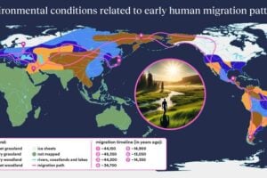
How Ancient Landscapes Guided Early Human Migration Out of Africa

Map of depth-integrated anthropogenic carbon Credit: Laura Cimoli/GLODAP

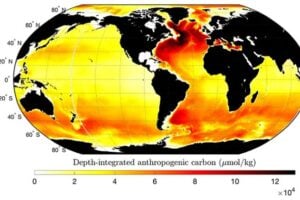
Giant underwater waves affect the ocean’s ability to store carbon

Illustration of critters impacted by Earth's warmth

Before global warming, was the Earth cooling down or heating up?

Substack subscription form sign up

Comments

  • Mark Mellinger on Living Plastic Can Self-Destruct on Command
  • Marie Feret on The Silent Frequency That Makes Old Buildings Feel Haunted
  • Dax on The Silent Frequency That Makes Old Buildings Feel Haunted
  • Karoly Mirnics on Common Prescription Drugs May Disrupt Cholesterol Pathways in the Womb and Raise Autism Risk
  • Aizen on Laziness helped lead to extinction of Homo erectus
© 2026 ScienceBlog.com | Follow our RSS / XML feed