A groundbreaking algorithm that automatically maps and tracks vital seagrass meadows from space could transform coastal ecosystem conservation efforts worldwide. Scientists from Xiamen University and Tulane University have developed a new approach that overcomes long-standing challenges in monitoring these critical but threatened underwater habitats.
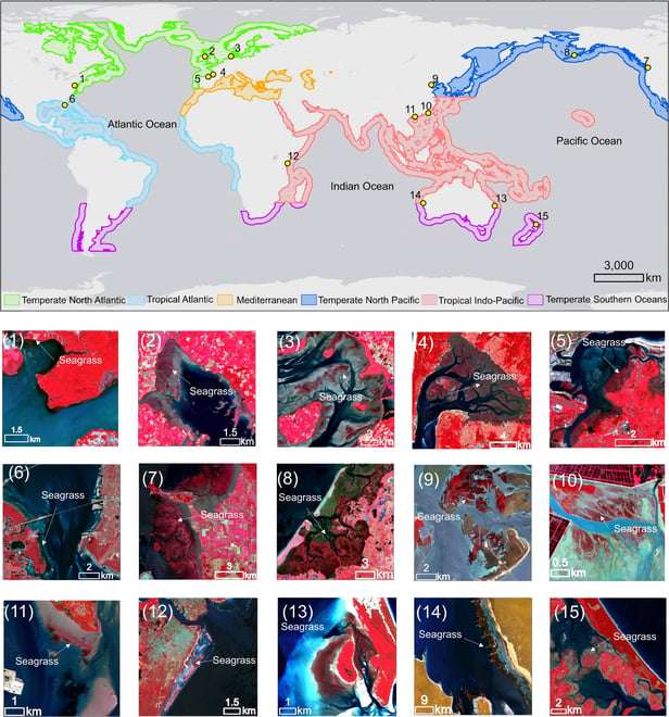
The new system, called Automatic Mapping through integrating Optical and SAR images for intertidal Seagrass meadows (AMOSS), leverages a unique combination of radar and optical satellite imagery to distinguish seagrass from other coastal vegetation. Published in the Journal of Remote Sensing, the study demonstrates the algorithm’s effectiveness across 15 global sites spanning tropical to sub-polar regions.
“Our AMOSS algorithm marks an advancement in seagrass monitoring. By automating the mapping process, we can now track seagrass changes globally with high accuracy and efficiency, which is crucial for protecting coastal ecosystems in the face of climate change,” the research team stated.
Unlike previous approaches requiring manual sample selection, AMOSS operates automatically, making it practical for large-scale monitoring programs.
Seagrass meadows represent some of Earth’s most valuable yet vulnerable ecosystems. They store vast amounts of carbon, provide critical habitat for marine species, and support coastal fisheries that feed millions of people. Despite their importance, seagrass monitoring has lagged behind that of other coastal environments like mangroves and salt marshes.
Traditional mapping methods struggle with seagrass because it shares similar spectral characteristics with neighboring vegetation and is affected by tidal variations. AMOSS overcomes these limitations by identifying key biophysical differences: seagrass lacks the upright structures of mangroves and salt marshes, giving it a distinct radar signature.
The algorithm achieved an impressive 84% overall accuracy across test sites, performing exceptionally well even in complex coastal landscapes. Unlike previous approaches requiring manual sample selection, AMOSS operates automatically, making it practical for large-scale monitoring programs.
As climate change and human activities continue threatening coastal ecosystems, this technology offers a powerful new tool for scientists and conservation managers to detect changes in seagrass distribution before irreversible damage occurs. The next frontier may involve integrating this approach into early warning systems that could help preserve these underwater meadows that are vital to ocean health and food security worldwide.
Discover more from SciChi
Subscribe to get the latest posts sent to your email.