

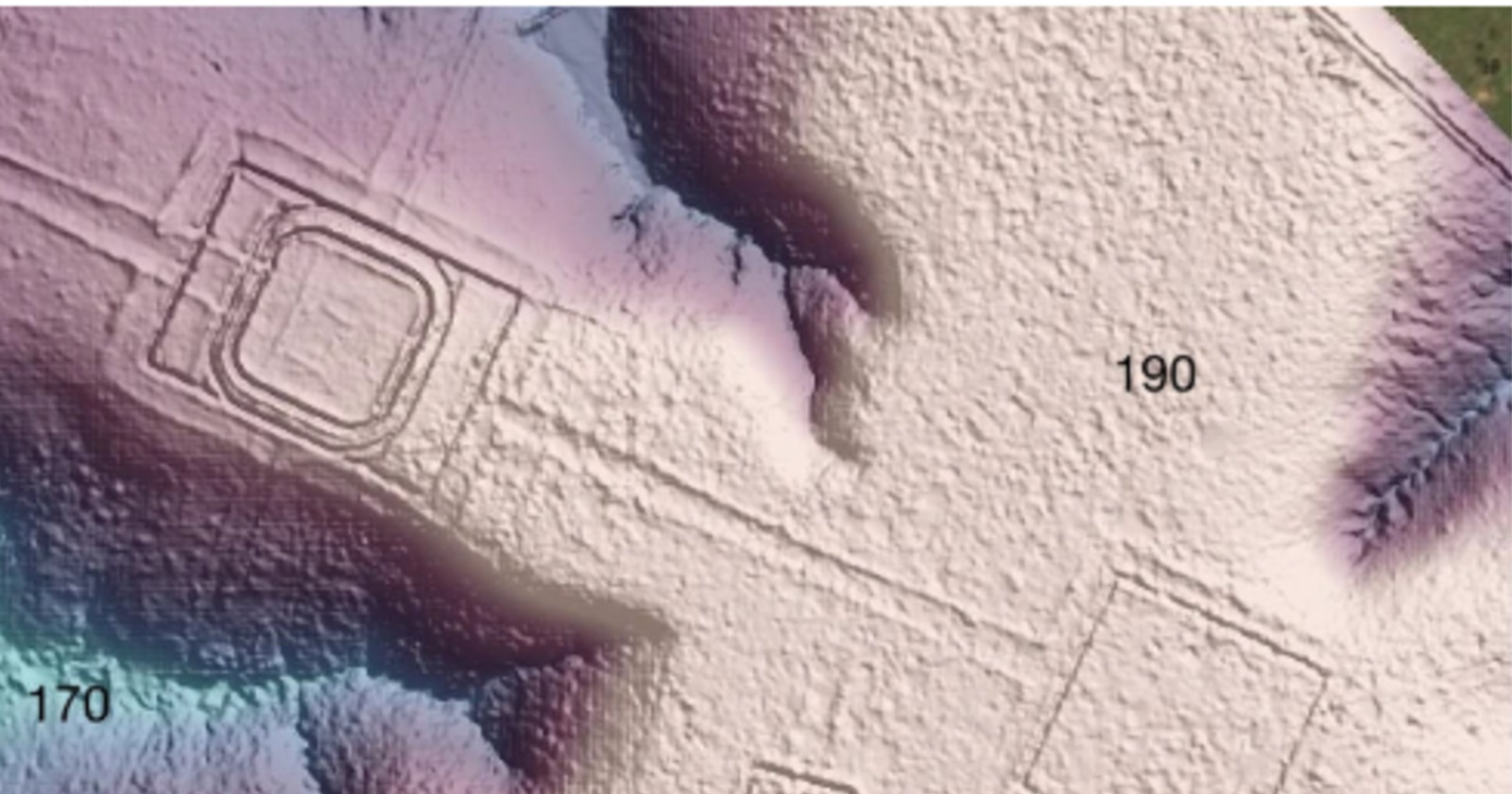
The first geometric earthworks in the Brazilian state of Acre were recorded in 1977. For most of the half century since, nearly every increase in the count came from the same place: ground where the forest had already been removed.
The first published tally was 60 structures. A later survey reported 200. By 2024 a systematic reading of satellite imagery and aerial photographs across about 134,000 square kilometres had reached 1,279.
That method had a built-in ceiling, and the researchers who used it said so. Earthworks show up in satellite pictures when there is nothing standing over them. Under closed canopy they are invisible, which means the map of an ancient civilization was tracking modern deforestation as much as anything else.
In June 2024 a survey aircraft began flying laser scanning lines over the canopy itself. The results, published on 29 July 2026 in Nature by Martti Pärssinen, Risto Kalliola, Alceu Ranzi and thirteen colleagues, document 432 earthworks along the flight lines, all but 36 of them new to the record. From that sample the team proposes that the wider region holds roughly 24,000 to 30,000 earthworks, and that the society which built them may have numbered between 1.25 and 3 million people around AD 100 to 300.
The scanned strips
The flights ran from 6 June to 1 July 2024 over Acre and Amazonas, covering 4,430 kilometres of flight line and 4,497 square kilometres of ground, about 1,740 square miles. A full-waveform laser scanner flown at roughly 1,125 metres returned an average of 31.2 measurement points per square metre, enough to model the forest floor at 50 centimetre resolution and identify earthworks from the shape of the terrain itself, with no photograph involved.
The structures are substantial. Geoglyphs, the ditched enclosures, typically enclose between 0.35 and 14 hectares, with the largest known example approaching 50 hectares, and their ditches run 9 to 13 metres wide and as much as 5 metres deep, roughly 16 feet. Most stand alone, though some form clusters of up to eight enclosures. The laser also showed that several long-known sites, including Piloto, D. Schaan and Fazenda Atlântica, have outer embankments that never appeared in aerial photographs, and that enclosures built with banks but no ditch are far more common than expected, precisely because they are the hardest type to see from above.
The authors describe these places as ceremonial and political centers built for gatherings, not for permanent residence, with no defensive works and no sign of continuous occupation.
The survey also found earthworks inside contemporary Indigenous territories and left them off the maps deliberately. They are absent from the published database, and two ditched enclosures near Lábrea are described without their locations.
The check on already-cleared ground
The largest numbers in the paper all depend on a smaller one. In the deforested parts of block 1, around Rio Branco, ground that had therefore already been searched from orbit, the laser recorded 156 earthworks where satellite imagery had shown 30.
That is a factor of five, and the paper reports the same factor across the full set of flight lines rather than in one lucky block. The implication is that the old count of 1,279 was low even for open ground, before any question of what the canopy hides.
Everything downstream rests on that multiplier, which is why the team also measured how much of the terrain the laser could read at all. West of 66 degrees west, 41.9 percent of the ground did not return enough points to show an ordinary earthwork, and east of that line the figure rose to 54.5 percent.
The grid samples a tenth of the block it crosses
The systematic part of the survey is six parallel lines, each roughly 445 kilometres long and one kilometre wide, spaced ten kilometres apart, and it produced 347 of the 432 structures. That grid covers about a tenth of the block it crosses, and every figure above 3,000 rests on the assumption that six further blocks resemble the one scanned in detail.
The authors present the regional figure as an extrapolation and report that their two routes to it, one from laser data and one from satellite data, differ by 23 percent across the core blocks, with individual blocks ranging from 52 percent below the average to 159.5 percent above it.
Two of the flight lines, about 800 kilometres in total, crossed the upland between the Purus and the Juruá rivers specifically to test whether the earthwork zone continued westward. They found nothing. The paper offers two readings and declines to choose between them: either the canopy there was too dense for the laser to build a usable terrain model, or there really are no earthworks on those lines, which would support the idea of uninhabited buffer zones between populated areas.
Not everything the laser found is Aquiry work either. Radiocarbon dating places the geoglyphs between 600 BC and AD 850 under Bayesian modelling, while mound villages and round banked enclosures in the same region date to after about AD 1000 to 1200. Of the 334 structures used for extrapolation, 120 ditched geoglyphs and 115 banked enclosures were assigned to the Aquiry and the rest treated as later, which is how the authors arrive at roughly two thirds of the regional total as the Aquiry share.
The arithmetic behind 23,760
With the sample and the multiplier in hand, the paper builds its regional figure in steps. Block 1 held 320 of the 347 structures; excluding thirteen that lie mostly outside the swaths and scaling the remainder to the full block gives about 3,070. Applied across seven relatively high-density blocks covering 85,000 square kilometres, that becomes 21,490, and adding a low-density periphery of 98,000 square kilometres at about a tenth of the density brings the total to 23,760.
The authors lean toward the higher of their two routes, because between 11.5 and 41.9 percent of the core area could not be read by laser at all. That route starts from satellites: multiplying the 1,256 structures previously detected in those blocks by five, then assuming the forested 77.5 percent of each block holds them at the same density, gives about 26,400, rising to 29,500 with the periphery.
The same exercise redraws the map. Bounding the Aquiry area by ditched enclosures, from Puerto Maldonado in Peru through Manoel Urbano to Lábrea, gives about 183,000 square kilometres, close to 70,700 square miles and triple the 60,000 estimated in 2009.
A 2023 modelling study in Science predicted that 10,272 to 23,648 earthwork sites remained undiscovered across all of Amazonia. This one cultural area, the authors argue, holds as many earthworks as that estimate allowed for the entire basin.
If each one took 300 people
The population figure is an inference from labor. No one counted people, and the authors describe it as a tentative estimate.
The densest overlap of calibrated radiocarbon dates falls around AD 100 to 300, with phase modelling suggesting roughly 60 percent of dated Aquiry earthworks were in simultaneous use then, and Kernel density estimates putting a quarter of all Aquiry earthworks in that construction window. If 16,660 Aquiry structures existed, and if a quarter to three fifths of them, so 4,165 to 10,000, were in use at the peak, and if each required about 300 people to build and maintain, the total comes to 1.25 to 3 million. Correcting for the ground the laser could not read, and for the 23 percent higher count the satellite route returns, raises that to 1.6 to 3.8 million. Each of those conditions is the authors’ own.
Heiko Prümers of the German Archaeological Institute, who has run comparable laser surveys in the Bolivian Amazon and was not part of this team, calls the study “really fascinating” but questions the step from structures to people. A high count of sites, he told Scientific American, could reflect a population that relocated often rather than one living at high density. He also notes it is unclear whether structures close together were counted separately or combined, which would move the totals.
They cross-check the 300 figure against later settlements in the same area, using mound village data from a 2020 study by José Iriarte and colleagues. Those villages average 1.28 hectares and 11.75 mounds, and if the mounds were multi-family longhouses holding at a minimum 25 people each, the arithmetic returns about 300 people per village. If instead every mound housed a single family, the regional population would fall closer to 250,000 to 600,000, a reading the authors call extremely unlikely.
One of the co-authors, Francisco Apurinã, works in Indigenous Studies at the University of Helsinki and is Apurinã himself. His people’s territory sits inside the earthwork zone, and their ceremonies gather 200 to 400 people across open spaces of one to two hectares. The team reports that Apurinã collaborators’ accounts of how many people a geoglyph was built for line up with the estimate.
Acre today holds 0.83 million people across 164,000 square kilometres, about 5.1 per square kilometre. The proposed Aquiry density across a comparable area is 7.1 to 16.5, and 13.6 to 32.6 in the core.
Earlier work had already shown that these builders left durable marks on the vegetation. A 2017 study in PNAS found the enclosures were cut into forest people had been managing for millennia, with palm species increasing by 28 and 30 percent after clearance events and staying elevated for some 3,000 years. Soil in the Aquiry area is among the most nutrient-rich in the whole of terra firme Amazonia.
The Acre flights turned up no single spectacular site. They turned up 800 kilometres of upland terrain model with nothing in it, sitting in the same dataset as 156 structures where 30 had been counted.
Between 41.9 and 54.5 percent of the ground beneath those flight lines never returned enough laser points to show an ordinary earthwork, depending on which side of 66 degrees west the aircraft was flying. The blank 800 kilometres sit somewhere inside that percentage, and the paper does not say where.
How much of southwest Amazonia has anyone looked at yet?