

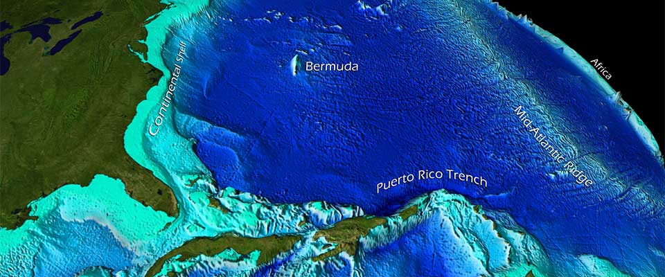
The longest mountain range on Earth is not the Andes, the Rockies or the Himalayas. It is the mid-ocean ridge, a linked system of underwater mountains that runs through every ocean basin and loops around the planet like stitching on a ball. NOAA’s National Ocean Service describes it as the longest mountain range on Earth, spanning 40,389 miles, or about 65,000 kilometres.
That fact feels wrong at first because the range is mostly invisible. Mountains are supposed to be seen from valleys, crossed by roads, climbed by people and photographed against the sky. The mid-ocean ridge lives under kilometres of seawater. Its peaks and rift valleys are not hidden by distance, but by an entire ocean.
NOAA estimates that about 90 percent of the ridge system lies beneath the ocean. Only rare places, such as Iceland, bring a piece of the ridge above sea level. Most of it is a submerged planet-scale landscape that humans know through sonar, satellite gravity data, deep-sea vehicles and the occasional glimpse from remotely operated cameras.
A mountain chain made by spreading plates
The ridge exists because Earth is restless. Along divergent plate boundaries, tectonic plates pull apart and hot material rises from the mantle. As magma reaches the seafloor and cools, it creates new oceanic crust. The result is a long, volcanic mountain system that marks where the ocean floor is being renewed.
The U.S. Geological Survey explains that divergent boundaries generate new crust as plates move away from each other. The Mid-Atlantic Ridge is one segment of that global system, running from the Arctic Ocean through the Atlantic and beyond the southern tip of Africa. Other connected ridges continue through the Indian, Pacific, Southern and Arctic oceans.
Seen on a global map, the ridge is not a straight line. It bends, offsets and branches where spreading centers meet transform faults and other plate boundaries. USGS has compared the trace of the ridge to the seam on a baseball, a simple image for a complicated planetary structure.
The tallest parts are not always the point
On land, mountain ranges are often judged by their highest summits. The Himalayas dominate imagination because Everest rises so far above sea level. The mid-ocean ridge asks for a different scale. Its importance is not a single peak. It is continuity, length and geological activity.
A typical ridge crest may sit thousands of metres below the surface and still rise dramatically above the surrounding abyssal plain. NOAA notes that the system is made of mountains and valleys formed as plates pull apart and magma fills the gap. To the ocean, these are not minor wrinkles. They are the architecture of the seafloor.
The ridge is also volcanic. The same NOAA account describes the global mid-ocean ridge system as the largest single volcanic feature on Earth, made of thousands of individual volcanoes or volcanic ridge segments. The eruptions are usually hidden from human view, but they are part of the machinery that keeps remaking the ocean crust.
Why it stayed hidden for so long
Humans mapped coastlines long before they understood the deep seafloor. For most of history, the ocean bottom was imagined as relatively featureless: a dark, muddy plain beneath shipping routes and fisheries. The true shape of the seafloor emerged slowly from sounding lines, echo sounders, wartime sonar and postwar oceanographic surveys.
The difficulty is not just depth. Light disappears quickly underwater. Pressure rises by roughly one atmosphere every 10 metres. Saltwater corrodes equipment. Ships move slowly. Sonar mapping takes time, and visual exploration requires vehicles that can survive darkness, cold and crushing pressure.
That is why the ridge can be both Earth’s longest mountain range and a place almost no one will ever see directly. A person can fly over the Himalayas, drive near the Andes or hike into the Rockies. To visit most of the mid-ocean ridge, they need a research vessel, a submersible, an ROV and a great deal of logistics.
A world still mostly unseen
The hiddenness is not poetic exaggeration. NOAA Ocean Exploration says only 28.7 percent of the global seafloor had been mapped with modern high-resolution technology as of April 2026. Satellite-derived maps cover the whole ocean floor in a broad sense, but they miss detail. They can hint at large features while leaving smaller seamounts, faults, vents and habitats unresolved.
Visual exploration is even more limited. The same NOAA page notes that explorers have visually observed less than 0.001 percent of the deep ocean seafloor. That means the longest mountain range on Earth runs through a realm that is mapped in outline but barely seen with human eyes or cameras.
This matters because the ridge is not just rock. Mid-ocean ridges host hydrothermal vents, chemical gradients, microbial communities and strange animals adapted to darkness and pressure. Some ecosystems around vents draw energy not from sunlight, but from chemical reactions involving fluids heated by Earth’s interior.
The ridge renews the planet’s skin
At the ridge crest, new crust forms. Away from the ridge, the seafloor cools, thickens and slowly moves across the ocean basin. Eventually, in many places, old oceanic crust sinks back into the mantle at subduction zones. The ocean floor is therefore not permanent in the way continents can seem permanent. It is made, moved and recycled.
That process changed how scientists understood Earth. Seafloor spreading helped explain continental drift, plate tectonics and the global pattern of earthquakes and volcanoes. The hidden mountain range was not an oddity at the bottom of the sea. It was evidence that the planet’s outer shell is mobile.
The scale is difficult to hold in mind. Sixty-five thousand kilometres is more than one and a half times Earth’s circumference. Yet much of that length lies beyond ordinary imagination, under black water, following boundaries where the crust is being born.
The mountain range without a skyline
There is something humbling about a mountain range that refuses the usual human terms. It has no continuous skyline. It has no tourist road. Its summits do not appear at sunrise. Most of its slopes will never receive footsteps, and most of its valleys will never be entered by a person.
Still, it is one of the defining structures of Earth. It shapes ocean basins, feeds volcanic activity, creates crust and gives scientists a live view of plate tectonics. The ridge is not less real because it is underwater. If anything, its invisibility makes it more revealing. The planet’s largest features are not always the ones built for human sight.
To imagine the mid-ocean ridge is to imagine Earth from below: not a blue surface wrapped around continents, but a dynamic world of rifts, lava, mineral vents and mountains in the dark. The longest range on the planet has been there all along, winding through a world we are only beginning to see.