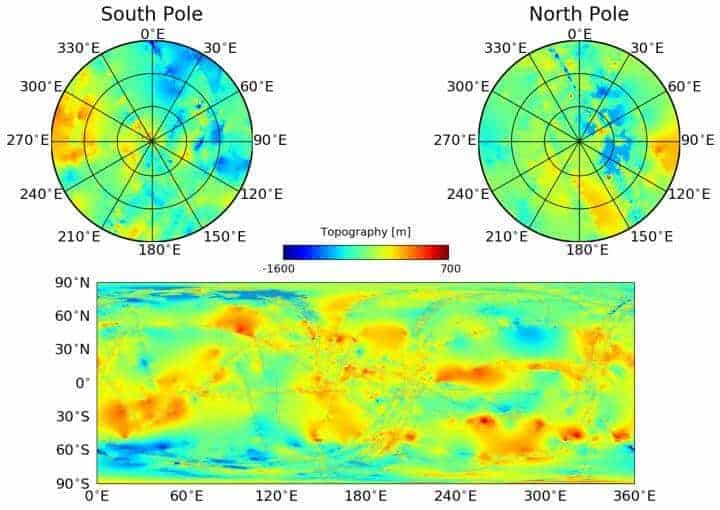
Using the now-complete Cassini data set, Cornell University astronomers have created a new global topographic map of Saturn’s moon Titan that has opened new windows into understanding its liquid flows and terrain. Two papers, recently published in Geophysical Review Letters, describe the map and discoveries arising from it.
Creating the map took about a year, according to doctoral student Paul Corlies, first author on “Titan’s Topography and Shape at the End of the Cassini Mission.” The map combines all of the Titan topography data from multiple sources. Since only about 9 percent of Titan has been observed in relatively high-resolution topography, with 25-30 percent of the topography imaged in lower resolution, the remainder of the moon was mapped using an interpolation algorithm and a global minimization process, which reduced errors such as those arising from spacecraft location.
The map revealed several new features on Titan, including new mountains, none higher than 700 meters. The map also provides a global view of the highs and lows of Titan’s topography, which enabled the scientists to confirm that two locations in the equatorial region of Titan are in fact depressions that could be either ancient, dried seas or cryovolcanic flows.
The map also revealed that Titan is a little bit flatter – more oblate – than was previously known, which suggests there is more variability in the thickness of Titan’s crust than previously thought.
“The main point of the work was to create a map for use by the scientific community,” said Corlies; within 30 minutes of the data set being available online, he began to receive inquiries on how to use it. The data set is downloadable in the form of the data that was observed, as well as that data plus interpolated data that was not observed. The map will be important for those modeling Titan’s climate, studying Titan’s shape and gravity, and testing interior models, as well as for those seeking to understand morphologic land forms on Titan.
Other Cornell authors on the paper are senior author Alex Hayes, assistant professor of astronomy, doctoral candidate Samuel Birch and research associate Valerio Poggiali.
The second paper, “Topographic Constraints on the Evolution and Connectivity of Titan’s Lacustrine Basins,” finds three important results using the new map’s topographical data.
The first result is that Titan’s three seas share a common equipotential surface, meaning they form a sea level, just as Earth’s oceans do. Either because there’s flow through the subsurface between the seas or because the channels between them allow enough liquid to pass through, the oceans on Titan are all at the same elevation.
“We’re measuring the elevation of a liquid surface on another body 10 astronomical units away from the sun to an accuracy of roughly 40 centimeters. Because we have such amazing accuracy we were able to see that between these two seas the elevation varied smoothly about 11 meters, relative to the center of mass of Titan, consistent with the expected change in the gravitational potential. We are measuring Titan’s geoid. This is the shape that the surface would take under the influence of gravity and rotation alone, which is the same shape that dominates Earth’s oceans,” said Hayes.
The paper’s second result proves a hypothesis that Hayes advanced in his first paper, in graduate school: that Titan’s lakes communicate with each other through the subsurface. Hayes and his team measured the elevation of lakes filled with liquid as well as those that are now dry, and found that lakes exist hundreds of meters above sea level, and that within a watershed, the floors of the empty lakes are all at higher elevations than the filled lakes in their vicinity.
“We don’t see any empty lakes that are below the local filled lakes because, if they did go below that level, they would be filled themselves. This suggests that there’s flow in the subsurface and that they are communicating with each other,” said Hayes. “It’s also telling us that there is liquid hydrocarbon stored on the subsurface of Titan.”
The paper’s final result raises a new mystery for Titan. Researchers found that the vast majority of Titan’s lakes sit in sharp-edged depressions that “literally look like you took a cookie cutter and cut out holes in Titan’s surface,” Hayes said. The lakes are surrounded by high ridges, hundreds of meters high in some places.
The lakes seem to be formed the way karst is on Earth, in places like the Florida Everglades, where underlying material dissolves and the surface collapses, forming holes in the ground. The lakes on Titan, like Earth’s karst, are topographically closed, with no inflow or outflow channels. But Earth karst does not have sharp, raised rims.
The shape of the lakes indicates a process called uniform scarp retreat, where the borders of the lakes are expanding by a constant amount each time. The largest lake in the south, for example, looks like a series of smaller empty lakes that have coalesced or conglomerated into one big feature.
“But if these things do grow outward, does that mean you’re destroying and recreating the rims all the time and that the rims are moving outward with it? Understanding these things is in my opinion the lynchpin to understanding the evolution of the polar basins on Titan,” said Hayes.
If our reporting has informed or inspired you, please consider making a donation. Every contribution, no matter the size, empowers us to continue delivering accurate, engaging, and trustworthy science and medical news. Independent journalism requires time, effort, and resources—your support ensures we can keep uncovering the stories that matter most to you.
Join us in making knowledge accessible and impactful. Thank you for standing with us!

