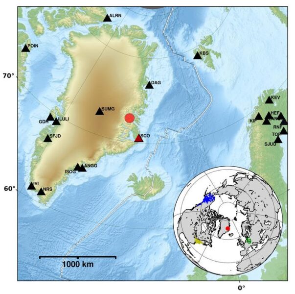
A massive tsunami struck Greenland’s east coast on September 16, 2023, leaving flood traces up to 200 meters high in certain areas. Researchers from the German Research Centre for Geosciences (GFZ) have now analyzed seismic data from this event, revealing an unprecedented phenomenon that lasted over a week.
Landslide Unleashes Colossal Wave
The tsunami was triggered by a large landslide in the uninhabited Dickson Fjord. Seismic stations as far as 5,000 kilometers away detected the initial shaking caused by the rockfall. However, what caught the researchers’ attention was an unusually persistent very long-period (VLP) signal that continued for more than seven days after the event.
Angela Carrillo Ponce, a doctoral student at GFZ and lead author of the study published in “The Seismic Records,” expressed her excitement about the discovery: “The mere fact that the VLP signal of a wave sloshing back and forth triggered by a landslide in a remote area of Greenland can be observed worldwide and for over a week is exciting. That’s why we in seismology have been most concerned with this signal.”
The landslide initially created a giant wave that spread through the entire fjord, reaching the offshore island of Ella over 50 kilometers away. Near the landslide entry point, the wave height exceeded 200 meters, with an average coastal height of 60 meters.
A Unique Standing Wave Phenomenon
As the massive wave rebounded off the steep fjord banks, it formed a standing wave that oscillated back and forth for more than a week. This standing wave, though only about 1 meter in height, produced the persistent VLP signal detected by seismometers worldwide.
While standing waves and their associated long-period signals are known to seismologists, they are typically linked to large glacier calving events. Carrillo Ponce noted, “In our case, we also registered a VLP signal. The unusual thing about it was the long duration.”
The research team was able to model the slow decay and dominant oscillation period of the VLP signals, corroborating their findings with satellite imagery. This analysis confirmed that the initial seismic signals corresponded well with the strength and direction of the rockfall that triggered the mega-tsunami.
Why it matters: This research provides valuable insights into the detection and analysis of large-scale geological events in remote areas. Understanding these phenomena is crucial as climate change accelerates glacier retreat and permafrost thaw, potentially increasing the risk of similar landslides and megatsunamis in the future.
The study’s findings open up new possibilities for identifying and studying past events of this nature. As glaciers that once filled entire valleys continue to retreat and permafrost thaws, the likelihood of landslides in these regions may increase. This, in turn, could elevate the risk of megatsunamis in vulnerable coastal areas.
The ability to detect and analyze these events using seismic data from distant stations could prove invaluable for early warning systems and risk assessment in mountainous coastal regions worldwide. Future research may focus on developing more sophisticated models to predict the occurrence and potential impact of such events, integrating seismic data with climate and geological information.
As climate change continues to reshape our planet’s landscape, studies like this one highlight the importance of ongoing monitoring and research to better understand and prepare for the potential consequences of these large-scale geological events.
If our reporting has informed or inspired you, please consider making a donation. Every contribution, no matter the size, empowers us to continue delivering accurate, engaging, and trustworthy science and medical news. Independent journalism requires time, effort, and resources—your support ensures we can keep uncovering the stories that matter most to you.
Join us in making knowledge accessible and impactful. Thank you for standing with us!

