Buried beneath the snow line,
these smouldering corpses
begin to glow.
Forgotten fires,
whose reanimated embers
burn brightly
across the tundra;
frozen bodies recoiling
at the heat
of their undying embrace.
Thawed to life by
distant warming
these undead hordes now
straddle horizons;
crimson fingers
flickering over
blue-veined memories,
as they dance
impossibly beyond
the water’s edge.
Nervously
we shift our gaze
towards a restless earth,
as unwanted resurrections
blaze across the landscape.
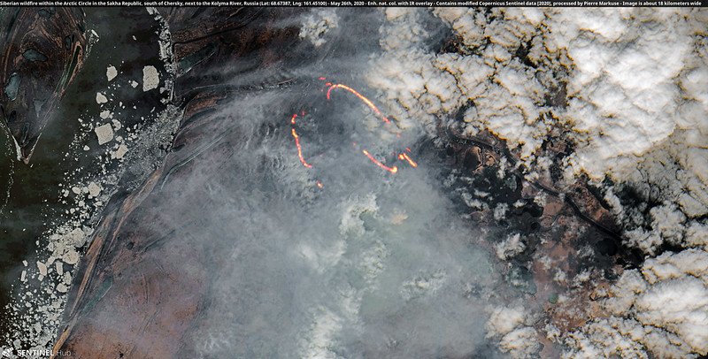
This poem is inspired by new research, which has found that the ways in which Arctic wildfires burn are potentially changing, with strong consequences for the global climate.
The 2020 Arctic wildfire season began two months early and was unprecedented in scope; in addition to the increase in severity and occurrence, two new features for the way in which these fires burn have also being identified. The first is what is known as holdover, or zombie, fires. These fires occur when fire from a previous growing season smoulders in carbon-rich peat underground over the winter, re-igniting on the surface several months (or even years) later, when the weather begins to warm. The second feature that has been observed is the occurrence of fire in what were previously thought to be fire-resistant landscapes. As the Arctic tundra becomes hotter and drier due to global warming, vegetation types such as sedges, grass, and moss, that are not typically thought of as fuels, start to catch fire. Even wet landscapes like bogs, fens, and marshes are also becoming vulnerable to burning in the changing climate.
More than half of the fires detected in Siberia this year were north of the Arctic Circle, occurring on permafrost that has a high percentage of ground ice. This type of permafrost contains enormous amounts of carbon, and global climate models currently do not account for their rapid thawing and subsequent release of greenhouse gases. At the local level, the rapid thawing of this permafrost would result in subsidence, floods, and landslides. Understanding these new fire regimes is therefore essential in order to better understand the impact that they will have on both the local and global level. However, while satellite imagery could potentially help to map the extent and timing of these new surface fires, measurements made on the ground are still needed to help calibrate any observations that are made by satellites. As such, addressing the gaps in our current understanding will require critical input from Indigenous and local communities, as well as collaboration across many different scientific disciplines.
ScienceBlog.com has no paywalls, no sponsored content, and no agenda beyond getting the science right. Every story here is written to inform, not to impress an advertiser or push a point of view.
Good science journalism takes time — reading the papers, checking the claims, finding researchers who can put findings in context. We do that work because we think it matters.
If you find this site useful, consider supporting it with a donation. Even a few dollars a month helps keep the coverage independent and free for everyone.