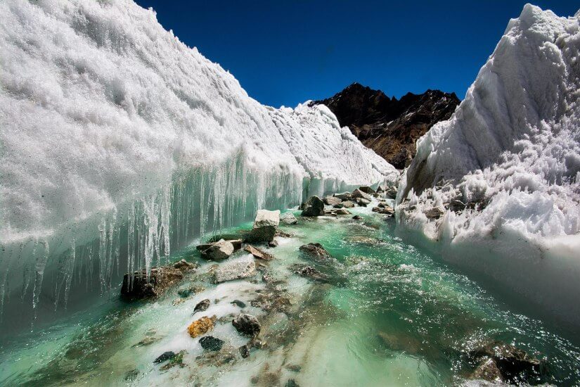
Somewhere above 4,000 metres on the Tibetan Plateau, a river bend that held its position for decades has begun to slip sideways. Not catastrophically, not in any single moment you could photograph. But over forty years of satellite imagery, the movement is unmistakable: channels that once migrated slowly across their floodplains are now doing so at nearly double the pace. The numbers are large enough to be startling. Between 1980 and 2020, the lateral migration rates of unconfined Himalayan river bends increased by roughly 97%. That is not a rounding error. That is a system in transition.
The Himalayas supply fresh water to somewhere around two billion people, feeding the rivers that drain across South and East Asia. Scientists sometimes call this region the Water Tower of Asia, which is apt enough, though it undersells the complexity of what is happening inside it.
A team led by researchers at China University of Geosciences, Beijing, spent four decades tracking how rivers move across three major drainage basins in the upper Himalayas. They measured 1,079 river bends covering about 1,582 kilometres of channel, watching for the full range of ways a river can reorganise itself: the slow sideways creep of meandering bends, the sudden shortcut called a cutoff (where a looping bend pinches off and the river takes a new, straighter route), and the rarer but more dramatic avulsion, in which a river abandons its channel almost entirely and breaks into new territory. They published their findings in Science in May 2026.
What they found was, in a word, coherent. The acceleration was not patchy or localised to particular tributaries. It was widespread, consistent, and closely matched the region’s rising temperatures.
The mechanism is not hard to follow, even if the details are intricate. The Himalayas are warming at nearly twice the global average rate. That warmth is doing two things simultaneously. It is melting glaciers, which increases the volume of water pouring into rivers and the sediment load those rivers carry. And it is thawing permafrost, which weakens the frozen riverbanks that had previously resisted lateral erosion. With more water pushing outward and less bank holding firm, river bends migrate faster, cut off more frequently, and occasionally leap into entirely new channels. Between 1980 and 2020, cutoff frequency rose by 115%, avulsion activity by 77%, and the rate of transitions between single-thread and braided channel patterns by 97%. The integrated index the researchers used to capture overall channel mobility more than doubled.
“The upper high Himalayas stand out as a region where climate warming and channel migration interact strongly,” said Dr. Zhongpeng Han of China University of Geosciences, “providing an opportunity to study the effects of a warming climate on river dynamics such as river meandering and planform morphodynamics.” Which is perhaps the academic way of saying: this place is changing faster than almost anywhere else, and it is showing us what warmer rivers look like before the rest of the world gets there.
Not Like the Arctic
The comparison with Arctic permafrost regions is instructive, and perhaps a little counterintuitive. You might expect that thawing frozen ground would accelerate river movement wherever it occurs. In the Arctic, though, the situation is more complicated. Warming there tends to promote the growth of shrubs and other vegetation along riverbanks, and that vegetation acts as a stabilising mat, holding sediment in place and actually slowing meandering rates in some areas. The Himalayan uplands offer no such buffer. The landscape above the treeline is sparse, rocky, and largely bare. When the permafrost that once cemented riverbanks together starts to thaw, there is nothing else holding things steady. The researchers describe this as a fundamental difference in the buffering capacity of the two environments, one that makes the Himalayas particularly sensitive to climate forcing.
The statistical analyses the team used were designed to distinguish climate-driven change from the other things that can make rivers move: local geology, the gradient of the channel, its width, or simply the internal dynamics of a meandering system that shifts on its own even without external prodding. Structural equation modelling let them separate these contributions. Climate warming, they found, dominates at regional scale. Geological controls and channel self-organisation contribute comparatively little to what is happening now.
A Signal in the Sediment
There is a biogeochemical dimension to all this that is easy to overlook. Floodplains store organic carbon, and when rivers migrate faster, they rework that carbon more quickly, moving it from stable storage back into the sediment flux. The researchers note that characteristic migration timescales have shortened by about 40% over the four decades they studied. That means organic carbon that might once have stayed locked in floodplain soils for centuries is cycling through the system rather faster now. The implications for regional carbon budgets are not yet fully worked out, but they are probably not trivial.
The more immediate concerns are practical. Roads, bridges, and pipelines tend to be built on the assumption that river channels stay roughly where they are. “For the billions who rely on Himalayan water sources, the acceleration of river dynamics documented in our study poses implications for water security, sediment-related hazards, and the stability of riparian infrastructure,” said Prof. Chengshan Wang, the study’s senior author. The region is not lightly populated or lightly developed. The infrastructure running through Himalayan valleys serves communities and supply chains that extend far beyond the mountains themselves.
What the researchers are calling for, in effect, is a recalibration of how engineers and planners think about river stability in this part of the world. Rivers that were treated as relatively fixed features in infrastructure assessments done a generation ago are now demonstrably more mobile. Whether that recalibration will happen fast enough, given the pace of both warming and development in the region, is rather less certain. The rivers, at least, are not waiting.
https://doi.org/10.1126/science.adg8401
Frequently Asked Questions
Why are Himalayan rivers shifting course faster than rivers in other cold regions like the Arctic?
The key difference is vegetation. In Arctic permafrost regions, warming tends to encourage the growth of shrubs along riverbanks, which actually stabilises the banks and slows river meandering. The Himalayan uplands are too high and sparse for this kind of plant cover, so when the frozen ground that holds riverbanks together starts to thaw, there is nothing to take its place. The Himalayas are essentially unguarded against this particular effect of warming.
Does river migration actually threaten communities, or is this mostly a scientific concern?
The threat is practical and immediate. Roads, bridges, pipelines, and other infrastructure in Himalayan valleys were typically built on the assumption that river channels would stay roughly where they were. With lateral migration rates nearly doubling over four decades, those assumptions are becoming unreliable, and the researchers specifically flag water security, sediment hazards, and infrastructure stability as areas of concern for the roughly two billion people who depend on rivers fed by Himalayan meltwater.
How do rivers actually “migrate” and why does it happen faster with more sediment?
River bends migrate sideways through a process of erosion on the outer bank and deposition on the inner bank, gradually shifting the channel’s position across the floodplain. More sediment in the water increases the load the river carries and alters the balance of erosion and deposition, while weakened frozen banks offer less resistance to lateral cutting. Together, these effects mean bends swing outward more quickly, cut off more often, and occasionally jump into entirely new channels through a process called avulsion.
Is this just about one river, or is the acceleration happening across the whole region?
The study covered three major river basins across the upper Himalayas, tracking more than 1,000 individual river bends over 1,582 kilometres of channel. The researchers specifically note that the acceleration was coherent and widespread, not confined to individual tributaries or local geological quirks. Statistical modelling confirmed that regional climate warming, rather than local factors like channel width or slope, is the dominant driver.
What does faster river migration mean for carbon stored in floodplain soils?
Floodplains lock up substantial amounts of organic carbon in their soils, sometimes for centuries. When rivers rework their floodplains more quickly, they disturb and mobilise that stored carbon, shortening what the researchers call “residence times.” The study found that characteristic migration timescales have shortened by around 40% over four decades, suggesting the region’s carbon storage is being disrupted in ways that could have broader biogeochemical consequences still being worked out.
ScienceBlog.com has no paywalls, no sponsored content, and no agenda beyond getting the science right. Every story here is written to inform, not to impress an advertiser or push a point of view.
Good science journalism takes time — reading the papers, checking the claims, finding researchers who can put findings in context. We do that work because we think it matters.
If you find this site useful, consider supporting it with a donation. Even a few dollars a month helps keep the coverage independent and free for everyone.