Two months after launch, Europe’s Biomass satellite has returned its first images—and they’re already revealing hidden secrets beneath some of the world’s most impenetrable forests. The spacecraft’s advanced radar can peer through dense Amazon canopies to measure the carbon locked inside tree trunks and branches, offering scientists an unprecedented tool for tracking how forests store and release carbon into the atmosphere.
The European Space Agency unveiled these inaugural images today at the Living Planet Symposium, showcasing the satellite’s ability to penetrate vegetation that has long remained opaque to traditional optical satellites. Beyond its primary forest mission, Biomass is already demonstrating unexpected capabilities—from mapping ancient riverbeds buried beneath Sahara sand to probing the internal structure of Antarctic ice.
Revolutionary Forest Vision Technology
Biomass carries the first P-band synthetic aperture radar ever deployed in space, a technology that can slice through forest canopies like an X-ray machine examining the human body. While optical satellites see only treetops, this long-wavelength radar reveals the entire forest structure from canopy to floor.
“Biomass is equipped with novel space technology, so we’ve been closely monitoring its performance in orbit, and we’re very pleased to report that everything is functioning smoothly and its first images are nothing short of spectacular,” explained Michael Fehringer, ESA’s Biomass Project Manager. The satellite remains in its commissioning phase, with scientists still fine-tuning its instruments for maximum precision.
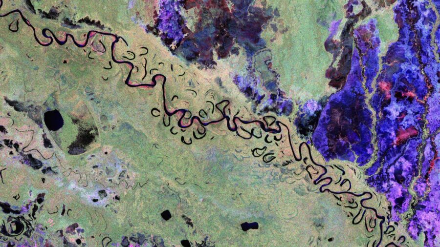
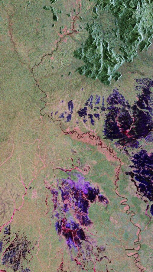
The radar’s different polarization channels create vivid, color-coded maps where green represents rainforest, red indicates forested floodplains and wetlands, and blue-purple marks grasslands. Black areas reveal rivers and lakes cutting through the landscape.
Tracking Deforestation in Real Time
One striking image captures Bolivia’s forests, where the country ranks among the world’s highest for primary forest loss due to agricultural expansion. The radar reveals the meandering Beni River as it flows from the Andes across Bolivian lowlands toward Brazil—a perfect example of the wild, undammed waterways that characterize much of the Amazon Basin.
The satellite’s true power emerges when combining multiple observations of the same area over time. This technique allows scientists to calculate precise forest height and biomass measurements, translating directly into carbon storage estimates that are crucial for climate modeling.
Key Capabilities Revealed in First Images
- Penetrates up to 5 meters through dry desert sand to map buried geological features
- Detects forest floor topography through dense canopy cover
- Measures internal ice structure and velocity in polar regions
- Distinguishes between forest types, wetlands, and grasslands with color-coded precision
- Tracks deforestation patterns invisible to optical satellites
Beyond Forests: Desert Archaeology and Ice Science
Perhaps most surprisingly, Biomass is proving valuable far beyond its forest mandate. Images of Chad’s Sahara Desert reveal intricate subsurface structures, including ancient riverbeds and lake formations that could help locate fossil water resources in arid regions. The radar’s five-meter sand penetration capability opens entirely new possibilities for desert archaeology and water prospecting.
In Antarctica, the satellite captured detailed views of the Transantarctic Mountains and Nimrod Glacier flowing into the Ross Ice Shelf. The long radar wavelengths can probe deep into ice, potentially revealing internal structure and flow dynamics that shorter wavelengths cannot detect.
Climate Science Applications
Director of Earth Observation Programmes Simonetta Cheli emphasized the mission’s broader implications: “We fully expect that this new mission will provide a groundbreaking leap in our ability to understand Earth’s forests—combining cutting-edge radar technology with the scientific excellence that will unlock vital insights into carbon storage, climate change, and the health of our planet’s precious forest ecosystems.”
The timing couldn’t be more critical. As climate negotiations intensify and carbon markets expand, accurate forest carbon measurements have become essential for verifying climate commitments and understanding the planet’s natural carbon cycle.
While these commissioning-phase images cannot yet support quantitative scientific analysis, they demonstrate that Biomass is well positioned to fulfill its promise of transforming forest monitoring from space. Once fully operational, the satellite will provide the precise, global forest carbon data that climate scientists have long sought—turning trees into measurable climate assets visible from 400 miles above Earth.
Discover more from European Space Agency Tracker
Subscribe to get the latest posts sent to your email.