In an advance that could transform how cities maintain their underground infrastructure, South Korean researchers have developed a satellite-based monitoring system that promises to cut maintenance costs by over 30% while eliminating dangerous blind spots in urban monitoring.
The innovation comes at a crucial time as cities worldwide grapple with aging infrastructure and increasingly complex underground development projects. The technology, developed by the Korea Institute of Civil Engineering and Building Technology (KICT), uses satellite Synthetic Aperture Radar (SAR) data to detect minute ground movements that could signal potential infrastructure problems.
“The number of facilities requiring maintenance is increasing,” says Dr. Sungpil Hwang, who led the research. “It is expected that using satellite SAR data will enable cost-effective and efficient maintenance.”
The system’s effectiveness was demonstrated in two major urban projects: the Busan Mandeok-Centum underground road and the GTX-A metropolitan express railway in the Seoul Metropolitan Area. Researchers discovered concerning ground displacement patterns, particularly near the confluence of the Oncheon Stream and Suyeong River in Busan, where rapid subsidence of 2 centimeters occurred in just one year after July 2022.
Space-Age Solution to Ground-Level Problems
The technology leverages free data from the European Space Agency’s Sentinel satellites, making it a cost-effective solution for cash-strapped municipalities. Using advanced radar imaging, the system can monitor vast urban areas under any weather conditions, day or night.
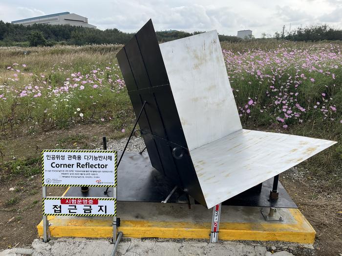
In a 2024 trial at a waste disposal facility, conducted jointly by KICT and the University of Tokyo, researchers overcame a significant challenge in wide-area monitoring. By installing special reflective markers called scatterers, they achieved signal strength more than 15dB higher than surrounding areas, enabling precise monitoring even in areas with dense vegetation.
Urban Underground Revolution
The research comes as South Korea pushes ambitious underground infrastructure projects to combat surface-level congestion and pollution. The country joins a global trend of major underground initiatives, following projects like Boston’s Big Dig and Madrid’s M30.
However, the study revealed potential risks in current projects. Analysis of the Busan underground road project showed that some areas experienced subsidence exceeding the 25-millimeter safety threshold, highlighting the critical need for continuous monitoring.
Looking Ahead
KICT plans to expand the system’s application beyond its current scope. The technology could prove particularly valuable for monitoring difficult-to-access infrastructure, from waste landfills to extensive underground transportation networks.
The research, funded by the Ministry of Science and ICT (project no. 20240401-001), was published in the December 2024 issue of Sustainability. As cities worldwide face similar infrastructure challenges, this South Korean innovation could set a new standard for urban monitoring and maintenance.
The research was carried out under KICT Research Program project no. 20240401-001, “A Study on Monitoring Surface Displacement Using SAR Data from Satellite for Waste Landfill,” funded by the Ministry of Science and ICT.
ScienceBlog.com has no paywalls, no sponsored content, and no agenda beyond getting the science right. Every story here is written to inform, not to impress an advertiser or push a point of view.
Good science journalism takes time — reading the papers, checking the claims, finding researchers who can put findings in context. We do that work because we think it matters.
If you find this site useful, consider supporting it with a donation. Even a few dollars a month helps keep the coverage independent and free for everyone.