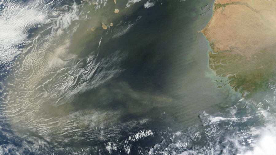
A massive plume of Saharan dust has completed its 5,000-mile journey to South Florida, bringing with it a natural defense against hurricane formation that scientists are only beginning to fully understand.
This phenomenon, known as the Saharan Air Layer, creates a “trifecta of atmospheric processes” that can shut down tropical storm development across the Atlantic Basin. However, this protective effect comes with a critical timing caveat that could determine whether the 2025 hurricane season becomes devastating or manageable for coastal communities.
The dust outbreak represents just one of many that will emerge from Africa’s coast every three to five days during peak season, sometimes covering areas larger than the continental United States.
The Dust Detective’s Discovery
The story begins nearly 60 years ago when Joseph Prospero, now an emeritus professor at the University of Miami, made a discovery that would reshape hurricane science. Prospero, known as “the father of dust,” founded the Barbados Atmospheric Chemistry Observatory specifically to track these massive dust plumes crossing the Atlantic.
“It certainly has a great impact on a number of processes, particularly the development of tropical cyclones and hurricanes,” said Prospero, who discovered the Saharan Air Layer. His specialized laboratory on Barbados’ east coast continues documenting how African dust influences everything from climate to air quality across the Caribbean Basin.
What makes Saharan dust unique among global dust storms is its intimate relationship with hurricane formation. “These [dust] outbreaks are often associated with easterly waves, and easterly waves are the nucleating phenomenon that can initiate the process of tropical storms,” Prospero explained. This connection makes Saharan dust outbreaks fundamentally different from dust storms elsewhere on Earth.
The Hurricane-Killing Trifecta
Jason Dunion, a meteorologist with the University of Miami and NOAA’s Hurricane Research Division, has spent years flying directly into these dust plumes aboard Hurricane Hunter aircraft to understand their storm-suppressing power.
“It’s a trifecta of atmospheric processes,” Dunion said, describing how the Saharan Air Layer systematically dismantles potential hurricanes through three distinct mechanisms.
The first weapon in this atmospheric arsenal is extreme dryness. The dust layer contains roughly 50% less moisture than typical tropical air, occupying a band two to two-and-a-half miles thick starting about a mile above sea level. “It’s super dry air,” Dunion noted. “Any clouds that run into that kind of dry air tend to collapse. So, the outbreaks make it very difficult for thunderstorms that could eventually become hurricanes to develop.”
The second factor involves powerful winds within the dust layer that create devastating wind shear for developing storms. “Thunderstorms are like skateboarders. They don’t want to be tipped over. They want to remain vertically aligned,” Dunion explained. The mid-level jet of strong winds, typically found between 6,500 to 14,500 feet, “starts to misalign the thunderstorm, causing the tropical cyclone vortex to tilt.”
The Thermal Lid Effect
The third component of this storm-killing combination involves temperature inversion. “The Saharan Air Layer is very warm, and all the dust in the layer absorbs solar energy,” Dunion said. “It’s that process that keeps the layer warm, and anytime you have warm air hiding in the upper atmosphere, it’s almost like a lid that makes it hard for clouds to break through.”
This thermal capping effect creates what meteorologists call a temperature inversion—warm air sitting above cooler air—which acts as an atmospheric ceiling that prevents thunderstorms from developing the vertical structure necessary for hurricane formation.
During peak activity, these dust outbreaks emerge from Africa’s coast with clockwork regularity, reaching as far west as Florida, Central America, and Texas. “Sometimes, larger than the Lower 48 states,” Dunion said, describing the vast scale of individual dust plumes that can blanket enormous swaths of the Atlantic Ocean.
The Critical August Transition
But here’s where the story takes a dramatic turn that could spell trouble for hurricane season. While dust outbreaks ramp up in mid-June and peak from late June to mid-August, they begin rapidly diminishing after mid-August—precisely when hurricane season traditionally becomes most dangerous.
“Once we get into August, those dust outbreaks start to become smaller, and they don’t reach as far to the west,” Dunion warned. “And that is probably one of the ingredients that then allows hurricanes to develop. It’s that switch point in the season that we must keep an eye on.”
This timing creates a crucial vulnerability window. Just as the protective dust shield weakens, other atmospheric conditions often become more favorable for hurricane development, potentially setting up late-season storms that face fewer natural barriers.
Beyond Hurricane Protection
The Saharan Air Layer’s influence extends far beyond storm suppression. Prospero emphasized that “the phenomenon has been well established to have an impact on many aspects of our lives—from our climate and human health to our safety in the sense of reduced visibility, which can complicate aircraft traffic and driving conditions on roads.”
The dust also plays crucial roles in ocean biogeochemistry, delivering nutrients that support marine ecosystems. “So, it’s proven to have a widespread and complex impact on the environment,” Prospero noted, expressing satisfaction that decades of research have revealed the dust’s far-reaching effects.
Current research led by Cassandra Gaston, who now heads the Barbados observatory, continues uncovering new aspects of dust transport. Recent field campaigns have measured “dust transport events that are some of the largest we have ever measured on the island as well as major intrusions of smoke from crop burns in Northern Africa,” Gaston reported.
The Climate Connection
The intensity of dust seasons varies significantly based on African rainfall patterns. “During drier years, when Northern African deserts receive less rainfall, more dust is transported westward and impacts us here in South Florida,” Gaston explained. This climate connection means that drought conditions in Africa can intensify dust activity thousands of miles away.
As climate patterns shift globally, understanding these connections becomes increasingly important for both hurricane forecasting and air quality management. The current dust outbreak serves as a reminder that Earth’s atmospheric systems remain interconnected in ways scientists are still discovering.
While coastal residents might feel temporarily relieved by nature’s hurricane shield, Dunion’s warning about the August transition serves as a sobering reminder: when the dust settles, the real hurricane season may just be beginning.
ScienceBlog.com has no paywalls, no sponsored content, and no agenda beyond getting the science right. Every story here is written to inform, not to impress an advertiser or push a point of view.
Good science journalism takes time — reading the papers, checking the claims, finding researchers who can put findings in context. We do that work because we think it matters.
If you find this site useful, consider supporting it with a donation. Even a few dollars a month helps keep the coverage independent and free for everyone.