Yasuo Ogawa has spent decades peering into the Earth’s crust, but the Marmara Sea presented a particular puzzle. For more than 250 years, this stretch of water separating Istanbul’s European and Asian sides has been seismically quiet, even while earthquakes have marched westward along the North Anatolian fault like dominoes falling in slow motion. The 1999 İzmit earthquake killed over 17,000 people just east of the sea, and the pattern suggests the Marmara region is next. Yet pinpointing where a future quake might rupture has proved maddeningly difficult.
The challenge is straightforward: you cannot easily place seismometers on a seafloor. Whilst land-based studies have mapped the North Anatolian fault’s behaviour for decades, the underwater sections remain poorly understood.
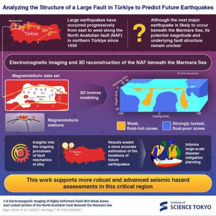
Ogawa and Tülay Kaya-Eken at Boğaziçi University decided to illuminate the hidden fault using a different approach entirely. Rather than measuring earthquake waves, they would map the electrical resistance of the rocks themselves, using magnetotelluric stations that detect subtle changes in Earth’s electric and magnetic fields caused by structures deep underground. They deployed more than 20 stations in and around the Marmara Sea, collecting data that would reveal how easily electricity flows through the crust at depths stretching to tens of kilometres. It’s a technique that has successfully identified fluid-filled fault zones at other major earthquake sites, from California’s San Andreas to Japan’s tremor-prone regions.
The team’s three-dimensional model revealed something striking. Low-resistivity zones, indicating the presence of water, snake along the northern branch of the fault beneath the Central and Çınarcık basins, matching up precisely with clusters of microearthquakes.
These conductive anomalies extend from about 5 kilometres down to the upper mantle. The estimated porosity of roughly 10 per cent suggests aqueous fluids coursing through fractured rock, weakening the brittle crust. Where there’s water under pressure in a fault zone, there’s typically seismic activity, as the fluid reduces friction and allows rock to slip more easily.
But the resistivity model also showed its inverse. High-resistivity zones, exceeding 300 ohm-metres, appear between the Central and Çınarcık basins and at the eastern and western extremities of the Marmara Sea, suggesting strong, locked sections of crust.
One resistive zone in particular caught the researchers’ attention. It sits beneath the Kumburgaz basin and extends vertically through the entire crustal layer, reaching down to the lithosphere. This is where two recent earthquakes struck: a magnitude 5.7 tremor in 2019 and a magnitude 6.2 event in 2025. The pattern emerging from the data suggests these locked zones are accumulating stress, held rigid by their lack of water whilst the surrounding weaker zones creep and slip. When they finally do rupture, they release that accumulated energy catastrophically.
Previous studies using GPS and seismic data have hinted at a creeping section in the western part of the Main Marmara fault. Ogawa and Kaya-Eken’s electrical resistivity model now provides the missing piece, showing the physical structure underlying that behaviour.
The locked zone between the Çınarcık and Central basins appears particularly ominous. It hasn’t ruptured in over 260 years.
Based on the fault length of roughly 60 kilometres, a seismogenic depth of 15 kilometres, and GPS measurements showing the fault slipping at 10 to 15 millimetres per year, the researchers estimate this section could produce an earthquake of magnitude 7.2 to 7.3. Istanbul, home to more than 15 million people, lies within 50 kilometres of this zone. Most buildings aren’t designed to withstand such a quake.
The model suggests future ruptures could nucleate at the boundaries between these weak, fluid-rich zones and the locked, resistive sections. It’s at these transitions where stress concentrates most intensely, where the Earth’s crust is simultaneously slipping and stuck, a mechanical contradiction that eventually must resolve itself through violence.
ScienceBlog.com has no paywalls, no sponsored content, and no agenda beyond getting the science right. Every story here is written to inform, not to impress an advertiser or push a point of view.
Good science journalism takes time — reading the papers, checking the claims, finding researchers who can put findings in context. We do that work because we think it matters.
If you find this site useful, consider supporting it with a donation. Even a few dollars a month helps keep the coverage independent and free for everyone.