Skip to content
ScienceBlog.com
  • Featured Blogs
    • EU Horizon Blog
    • ESA Tracker
    • Experimental Frontiers
    • Josh Mitteldorf’s Aging Matters
    • Dr. Lu Zhang’s Gondwanaland
    • NeuroEdge
    • NIAAA
    • SciChi
    • The Poetry of Science
    • Wild Science
  • Topics
    • Brain & Behavior
    • Earth, Energy & Environment
    • Health
    • Life & Non-humans
    • Physics & Mathematics
    • Social Sciences
    • Space
    • Technology
  • Our Substack
  • Follow Us!
    • Bluesky
    • Threads
    • FaceBook
    • Google News
    • Twitter/X
  • Contribute/Contact

Mars

Gypsum’s crystalline facies and sample handling. Images of the studied twinned selenite crystal and of the sample preparation and handling for optical microscopy, SEM-EDX, and LIMS analyses. (A) Smal crystal selenite (SC) and decimeter-sized twinned arrow-head selenite (TS) crystals show the darker re-entrant angle of the crystals (dashed black lines). (B) Large petrographic thin section of the re-entrant angle of the twinned selenite crystal marked in the blue rectangle in (A). It shows very turbid (vTL), turbid (TL) and limpid laminations (LL). (C) Small petrographic thin section of turbid laminae fixed on the LIMS sample holder with copper tape. (D) Gold coated sample on the LIMS sample holder.

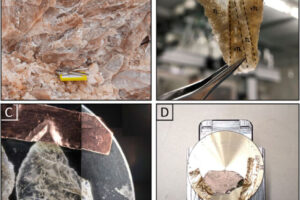
Laser-powered device tested on Earth could spot microbial fossils on Mars

a kitchen view onto the Martian landscape

Scientists Unlock Mars Mysteries with Kitchen Ingredients

Surrounded by frost, these Martian dunes in Mars northern hemisphere were captured from above by NASAs Mars Reconnaissance Orbiter using its HiRISE camera on Sept. 8, 2022. Credit: NASA/JPL-Caltech/University of Arizona

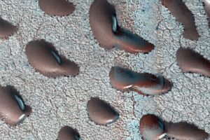
Mars Welcomes Spring with Avalanches, Ice Explosions and Swirling Dunes

This image taken by NASA’s Mars Reconnaissance Orbiter shows ice sheets at Mars’ south pole.

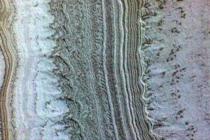
Mars Ice Deposits May Harbor Potential for Microbial Life

Gravity map of Mars. The red circles show prominent volcanoes on Mars and the black circles show impact crates with a diameter larger than a few 100 km. A gravity high signal is located in the volcanic Tharsis Region (the red area in the centre right of the image), which is surrounded by a ring of negative gravity anomaly (shown in blue).

Gravity study gives insights into hidden features beneath lost ocean of Mars and rising Olympus Mons

Here's a clearer version: An illustration shows the Martian interior beneath NASA's Insight lander. The top 5 kilometers of the crust seem to be dry, but a new study suggests there's a zone of fractured rock 11.5-20 kilometers below the surface that contains a significant amount of liquid water—more than what was thought to have filled ancient Martian oceans. (Illustration credit: J)

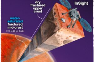
Hidden Martian Oceans: Vast Water Reserves Discovered Deep Below Surface

In July 2024, NASA's Perseverance rover found "leopard spots" on a reddish rock called "Cheyava Falls" in Mars' Jezero Crater. Scientists suggest these spots might indicate that chemical reactions in the rock billions of years ago could have supported microbial life. Other explanations are also being explored.

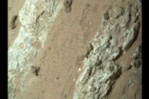
Perseverance Rover Uncovers Intriguing Rock on Mars with Potential Signs of Ancient Life

Syntrichia caninervis

Tough Desert Moss Could Pave the Way for Life on Mars

First meteoroid impact detected by NASA’s InSight mission; the image was taken by NASA’s Mars Reconnaissance Orbiter using its High-Resolution Imaging Science Experiment (HiRISE) camera.

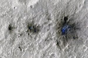
New class of Mars quakes reveals daily meteorite strikes

This simulated perspective oblique view shows Olympus Mons, the tallest volcano not only on Mars but in the entire solar system. The volcano measures some 600 km across.

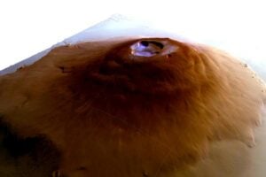
In a significant first, researchers detect water frost on solar system’s tallest volcanoes

This image taken by NASA’s Mars Reconnaissance Orbiter shows ice sheets at Mars’ south pole.

New research finds lake under Mars ice cap unlikely

Tracing the origins of organic matter in Martian sediments

Decoding Mars’ Organic Mysteries

MIT geologists determined the original orientation of many of the bedrock samples collected on Mars by the Perseverance rover, depicted in this image rendering. The findings can give scientists clues to the conditions in which the rocks originally formed. Credits:Image: NASA/JPL-Caltech

Study determines the original orientations of rocks drilled on Mars

Mars Perseverance Rover RIMFAX ground penetrating radar measurements of the Hawksbill Gap region of the Jezero Crater Western Delta, Mars. Hawksbill Gap.

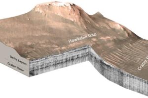
Confirmation of ancient lake on Mars builds excitement for Perseverance rover’s samples

Older posts
Page1 Page2 Next →
Substack subscription form sign up

Comments

  • Kidreadytobreed on Global warming reduces available wind energy
  • James on Global warming reduces available wind energy
  • James on Global warming reduces available wind energy
  • Booklet AI on Key to online education: Test early and often
  • Karoly Mirnics on Common Prescription Drugs May Disrupt Cholesterol Pathways in the Womb and Raise Autism Risk
© 2026 ScienceBlog.com | Follow our RSS / XML feed