
Key Takeaways
- The study uses data from over 230,000 GPS locations of polar bears to identify critical habitats for conservation in the Arctic.
- Polar bears serve as an umbrella species, and protecting them may also protect numerous other Arctic species.
- Researchers recommend establishing dynamic marine protected areas that shift boundaries based on seasonal ice patterns.
- The timing of the study coincides with plans to explore a national marine conservation area amid increasing industrial activity.
- Though polar bears face threats from climate change, the data offers a path for ongoing conservation efforts and ecosystem protection.
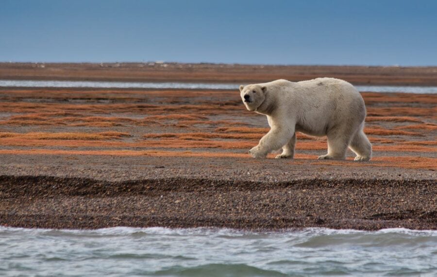
The collar weighs about a kilogram and transmits six times a day. Fitted to an adult female somewhere in western Hudson Bay, it relays her position to a satellite, which passes that fix to a server, which adds it to a database that now contains more than 230,000 such locations collected from 355 individual bears across two decades of fieldwork. For most of its existence, that dataset existed to answer a fairly specific question: where do polar bears go? A new study published today in Arctic Science argues it can answer a considerably larger one. Where should we protect the Arctic?
The answer, according to researchers at the University of Alberta and San Diego Zoo Wildlife Alliance, is roughly the same place.
The concept behind this logic is called an umbrella species, and it has a long and occasionally contentious history in conservation biology. The basic idea is that some animals, by virtue of their size, their ecological position, and the breadth of their movements, effectively stand in for the wider community of species they live among. Protect the jaguar’s range and you protect the forest. Protect the giant panda’s bamboo habitat and you protect hundreds of other species that shelter in it. The umbrella metaphor is appealing because it turns a hard problem (we need data on thousands of species to design a sensible protected area) into a tractable one (we have excellent data on this one species, so let’s use it). It is, in effect, a shortcut.
Shortcuts in conservation have a poor reputation. They tend to work in some contexts and fail in others in ways that are not always predictable beforehand.
What makes the polar bear case compelling is the quality of the data. Andrew Derocher, a biological sciences professor at the University of Alberta who has spent decades studying the western Hudson Bay subpopulation, and Nicholas Pilfold, a conservation scientist at San Diego Zoo Wildlife Alliance, led a team that assessed polar bears against 13 criteria that ecologists use to evaluate umbrella species. The bears satisfied 10 with strong support, one with moderate support. They failed two: there’s genuine uncertainty about whether the bears qualify as a keystone species (their prey might fit that description better), and the long-term persistence question is real, given predictions of significant population decline in Hudson Bay by mid-century under continued warming.
On the other 11 criteria, the case is fairly solid. Polar bears have the largest home ranges of any bear species, averaging around 300,000 square kilometres per individual in this subpopulation. They’re top predators in a system where the energy flow runs from sea ice algae to ringed seals to bears, with the bears themselves providing a secondary service to the ecosystem by feeding scavengers. Because they rarely cache their kills, a bear’s abandoned carcass feeds Arctic foxes, wolves, ravens, and several species of gull that follow them onto the ice. Their movements are migratory, linking marine and terrestrial habitats, which means that tracking them traces an outline around an unusually broad slice of Arctic biodiversity. And their biology, more than perhaps any other large Arctic marine mammal, is exceptionally well-documented. You can’t make a sensible conservation argument from a data gap. With polar bears in Hudson Bay, there is no data gap.
An umbrella species is one whose protection also shields a broader community of other species sharing the same habitat. The idea is that a well-studied animal with a large range can serve as a proxy for biodiversity data that doesn’t exist, letting conservationists draw meaningful protected area boundaries without needing independent surveys of thousands of other species. It works best when the focal species is a top predator with extensive, well-documented movements.
The team analysed tracking data from 355 polar bears monitored between 2004 and 2023, accumulating more than 230,000 GPS locations. They calculated utilization distributions, essentially probability maps of where the bears concentrated their time on the sea ice during each season, and found that the core 50 percent use area covered roughly 66,000 square kilometres of offshore habitat near Cape Churchill. High seasonal overlap suggested a single fixed MPA could capture most of that critical area.
The authors acknowledge this tension directly. They argue that the data collected now can establish protected area boundaries that will continue serving ecosystem functions even if the polar bear population itself declines. High-use polar bear habitat reflects the distribution of prey species, productive sea ice zones, and other biodiversity that warrants protection regardless. Think of it less as saving the umbrella and more as using the umbrella to mark where to stand before the rain arrives.
Polar bears rarely cache their kills and typically abandon carcasses after feeding. This behaviour creates a regular supply of carrion across the sea ice, feeding Arctic foxes, wolves, ravens, glaucous gulls, and ivory gulls that follow bears or patrol the same areas. Beyond the scavenging chain, polar bears also create a kind of landscape of fear that influences where ringed seals move and how they behave, shaping the spatial structure of the broader ecosystem.
Rather than fixed boundaries, a dynamic MPA shifts its edges in response to seasonal sea ice patterns, following the movements of the bears and the underlying biological productivity they track. In practice this would likely mean establishing a core protected zone near Cape Churchill while allowing seasonal adjustment of the wider boundary based on real-time ice data and updated telemetry. This approach is considered more robust to the kind of rapid environmental change the Arctic is experiencing, since fixed boundaries set against today’s conditions may not map onto the ecosystem’s most critical areas in a decade’s time.
“By leveraging the extensive data we have on polar bears, we can help design MPAs that safeguard both the bears and the vast network of Arctic species that rely on them,” says Pilfold. Dynamic marine protected areas, he argues, offer the flexibility that a rapidly shifting Arctic environment demands.
The practical output of the study is a candidate marine protected area near Cape Churchill on the Manitoba coast. Using the 20-year telemetry dataset, the researchers calculated utilization distributions: essentially, probability maps showing where bears spend the most time on the sea ice. The 50% utilization distribution, capturing the core use area across all seasons, covered about 66,000 square kilometres of offshore habitat. Seasonal variation existed, as you’d expect, with bears contracting into smaller areas during late winter (when feeding and mating concentrate activity) and expanding during freeze-up and breakup as ice conditions dictate. But the overlap between seasons was high, mean Bhattacharyya’s affinity around 0.88 out of a possible 1, suggesting that a single well-placed MPA might reasonably cover the most ecologically critical area throughout the year. A dynamic management approach, with adjustable boundaries tracking seasonal ice patterns, would do better still.
The timing is not coincidental. Last month, Manitoba Premier Wab Kinew announced funding to explore the establishment of a national marine conservation area in western Hudson Bay. The port of Churchill, meanwhile, has been looking at expanded year-round commercial shipping operations, which would increase industrial activity through exactly the area the study identifies as highest-value bear habitat. The bears, in this sense, are being asked to do double duty: to justify their own protection while simultaneously anchoring the protection of everything around them.
There is a complication, and the authors are candid about it. The same climate trajectory that makes Arctic protection urgent is the one most threatening to the species being used as the conservation anchor. Western Hudson Bay polar bears have already declined by roughly 30 percent since the 1980s, a decline closely correlated with the shortening of the sea ice season. Projections suggest that ice-free periods may become too long for the subpopulation to sustain itself if global temperatures exceed roughly 1.6 to 2.6 degrees of warming above pre-industrial levels. An umbrella species that disappears is, obviously, no longer an umbrella.
Derocher is direct about this tension. “In the rapidly warming Arctic, marine ecosystems will be stressed by the additive effects of industrial activity and polar bear location data provide a path to designing marine protected areas,” he says. The logic is essentially a race: use the data while we have it, establish the boundaries now, and let the protected area serve its ecosystem function even if its original focal species eventually retreats. High-value polar bear habitat, after all, is not high-value because of the bears alone. It’s high-value because of what’s underneath: the seal populations, the sea ice algae, the fish, the birds, the whole vertical structure of an Arctic marine ecosystem that mostly lacks the kind of monitoring data that would let us find it independently. The bear is, in a way, pointing at something much larger than itself.
The authors are careful not to oversell the analysis. They recommend overlaying the polar bear utilization maps with whatever distribution data exist for seals, beluga whales, seabirds, and other species before drawing any final MPA boundaries. They flag that the dataset is skewed toward adult females (the bears most amenable to collar-fitting) and that harbour seals and belugas use slightly different areas of the bay that the bear data doesn’t fully capture. Inuit traditional knowledge and Indigenous land-use data, they argue, should inform any final designation. The study is a starting point, not a blueprint.
What it does establish is that two decades of patient fieldwork in one of the more uncomfortable research environments on Earth has produced something with conservation value beyond what anyone originally designed it for. A collar clicking away in the dark of a Hudson Bay winter, transmitting its daily fix, turns out to have been mapping the shape of an ecosystem all along.
DOI: 10.1139/as-2025-0077
Discover more from Wild Science
Subscribe to get the latest posts sent to your email.