In addition to being the last horizon for adventurers and spiritual seekers, the Himalaya region is a prime location for understanding geological processes. It hosts world-class mineral deposits of copper, lead, zinc, gold and silver, as well as rarer elements like lithium, antimony and chrome, that are essential to modern technology. The uplift of the Tibetan plateau even affects global climate by influencing atmospheric circulation and the development of seasonal monsoons.
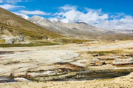
In a north-south rift above a tear in the Indian plate, boiling springs bring fluids up 50 miles from the upwelling hot mantle, and the wide area of baked ground shows the high temperatures due to rifting. (Image credit: Courtesy Simon Klemperer)
Yet despite its importance, scientists still don’t fully understand the geological processes contributing to the region’s formation. “The physical and political inaccessibility of Tibet has limited scientific study, so most field experiments have either been too localized to understand the big picture or they’ve lacked sufficient resolution at depths to properly understand the processes,” said Simon Klemperer, a geophysics professor at Stanford’s School of Earth, Energy & Environmental Sciences (Stanford Earth).
Now, new seismic data gathered by Klemperer and his colleagues provides the first west-to-east view of the subsurface where India and Asia collide. The research contributes to an ongoing debate over the structure of the Himalaya collision zone, the only place on Earth where continental plates continue crashing today – and the source of catastrophes like the 2015 Gorkha earthquake that killed about 9,000 people and injured thousands more.
The new seismic images suggest that two competing processes are simultaneously operating beneath the collision zone: movement of one tectonic plate under another, as well as thinning and collapse of the crust. The research, conducted by scientists at Stanford University and the Chinese Academy of Geological Sciences, was published in Proceedings of the National Academy of Sciences Sept. 21.
The study marks the first time that scientists have collected truly credible images of what’s called an along-strike, or longitudinal, variation in the Himalaya collision zone, co-author Klemperer said.
As the Indian plate collides with Asia it forms Tibet, the highest and largest mountain plateau on the planet. This process started very recently in geological history, about 57 million years ago. Researchers have proposed various explanations for its formation, such as a thickening of the Earth’s crust caused by the Indian plate forcing its way beneath the Tibetan Plateau.
To test these hypotheses, researchers began the major logistical effort of installing new seismic recorders in 2011 in order to resolve details that might have been previously overlooked. Importantly, the new recorders were installed from east to west across Tibet; traditionally, they had only been deployed from north to south because that is the direction the country’s valleys are oriented and thus the direction that roads have historically been built.
The final images, pieced together from recordings by 159 new seismometers closely spaced along two 620-mile long profiles, reveal where the Indian crust has deep tears associated with the curvature of the Himalayan arc.
“We’re seeing at a much finer scale what we never saw before,” Klemperer said. “It took a heroic effort to install closely spaced seismometers across the mountains, instead of along the valleys, to collect data in the west-east direction and make this research possible.”
Building and breaking
As the Indian tectonic plate moves from the south, the mantle, the thickest and strongest part of the plate, is dipping beneath the Tibetan plateau. The new analyses reveal that this process is causing small parts of the Indian plate to break off beneath two of the surface rifts, likely creating tears in the plate – similar to how a truck barreling through a narrow gap between two trees might chip off pieces of tree trunk. The location of such tears can be critical for understanding how far a major earthquake like Gorkha will spread.
“These transitions, these jumps between the faults, are so important and they’re at a scale that we don’t normally notice until after an earthquake has happened,” Klemperer said.
An unusual aspect of Tibet involves the occurrence of very deep earthquakes, more than 40 miles below the surface. Using their seismic data, the researchers found associations between the plate tears and the occurrence of those deep quakes.
The research also explains why the strength of gravity varies in different parts of the collision zone. The co-authors hypothesized that after the small pieces dropped off of the Indian plate, softer material from underneath bubbled up, creating mass imbalances in the India-Tibet collision zone.
A natural laboratory
The India-Tibet region also provides insight into how parts of the eastern U.S. could have been formed through continental collisions about a billion years ago.
“The only way to understand what might have happened in eastern North America today is to come to Tibet,” Klemperer said. “For geologists, this is the one big continental collision that is taking place on Earth today – it’s this natural laboratory where we can study these processes.”
Klemperer is also a professor of geological sciences, by courtesy.
The research was supported by the China National Natural Science Foundation, the Chinese Geological Survey and the U.S. National Science Foundation.
To read all stories about Stanford science, subscribe to the biweekly Stanford Science Digest.
ScienceBlog.com has no paywalls, no sponsored content, and no agenda beyond getting the science right. Every story here is written to inform, not to impress an advertiser or push a point of view.
Good science journalism takes time — reading the papers, checking the claims, finding researchers who can put findings in context. We do that work because we think it matters.
If you find this site useful, consider supporting it with a donation. Even a few dollars a month helps keep the coverage independent and free for everyone.