A massive subglacial flood in northern Greenland punched its way up through nearly 85 meters of ice, bursting onto the surface in a rare and violent event that reshaped the landscape.
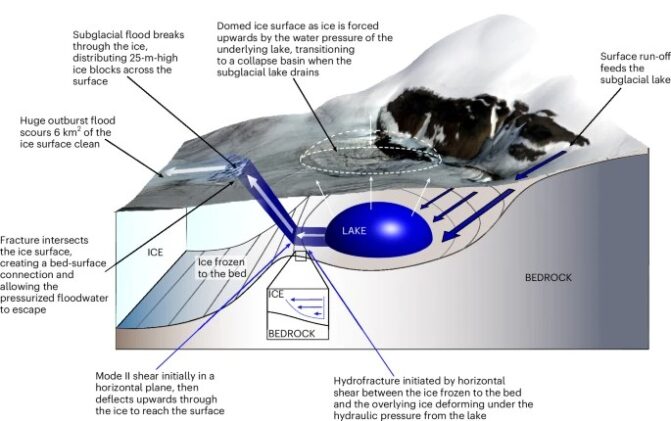
The eruption, triggered by the sudden drainage of a hidden lake beneath the ice sheet, fractured and distorted an area the size of 54 football fields, scattering 25-meter-high ice blocks and scouring a swath of clean, exposed ice nearly twice the size of Central Park. This dramatic discovery, described in a new Nature Geoscience study, reveals an unrecognized form of glacial collapse that could alter future predictions of sea-level rise.
Flood From Below: A Hidden Threat
The event occurred in the summer of 2014 but was only recently identified by an international team led by Lancaster University. Using high-resolution satellite data and digital elevation models, the researchers tracked the sudden appearance of a 2 km2 crater in the ice sheet surface as 90 million cubic meters of water—equivalent to nine hours of Niagara Falls at peak flow—drained from a previously unknown subglacial lake.
What stunned scientists was where the water went next. Instead of flowing beneath the glacier, as models would suggest, it surged upward, rupturing the surface of the ice.
“When we first saw this, because it was so unexpected, we thought there was an issue with our data,” said lead author Dr. Jade Bowling. “However, as we went deeper into our analysis, it became clear that what we were observing was the aftermath of a huge flood of water escaping from underneath the ice.”
A Surface Eruption Unlike Any Seen Before
Roughly one kilometer downstream of the collapse site, the team found an expanse of fractured and disturbed ice, measuring 385,000 square meters. The surface was broken into jagged ridges and massive uplifted blocks—clear evidence that a forceful jet of water had erupted from below.
- The flood drained in just 10 days during July 2014
- A collapse basin 85 meters deep formed over 2 square kilometers
- The outburst scoured 6 square kilometers of ice surface
- Satellite imagery shows the lake feature existed since at least 1985
- Similar drainage in 1990 did not break the surface, making the 2014 event unique
Rethinking How Ice Sheets Drain
Until now, the flow of meltwater beneath Greenland’s ice sheet was thought to be a one-way path from surface to bedrock, then out to sea. This discovery flips that model. The team proposes that under extreme pressure, water can fracture frozen basal ice and travel back up to the surface. Their modeling suggests the bed was cold and previously thought impermeable to such an event.
“It has taught us new and unexpected things about the way that ice sheets can respond to extreme inputs of surface meltwater,” said Dr. Amber Leeson. “And emphasised the need to better understand the ice sheet’s complex hydrological system, both now and in the future.”
Even more intriguingly, the flood’s effects didn’t stop at the eruption. The surge of water likely re-entered the glacier system farther downstream, possibly contributing to a large calving event at the glacier terminus and triggering a 63 percent seasonal drop in ice speed.
Implications for a Warming Arctic
This discovery raises urgent questions: Could more such floods occur as warming accelerates surface melt? Are today’s models missing a critical form of glacial vulnerability? According to co-author Prof. Mal McMillan:
“Satellites represent an essential tool for monitoring the impacts of climate change, and provide critical information to build realistic models of how our planet may change in the future.”
With up to 68 percent of Greenland’s ice bed predicted to be frozen or thermally uncertain, the potential for similar eruptions may increase as more surface meltwater infiltrates these poorly understood zones. The researchers call for a renewed focus on the ice sheet’s subglacial plumbing to better predict its future behavior.
The study was a collaboration between 15 institutions and funded by the UK Natural Environment Research Council, European Space Agency, and UK Research and Innovation.
Journal Reference
Bowling JS, McMillan M, Leeson AA, et al. “Outburst of a subglacial flood from the surface of the Greenland Ice Sheet.” Nature Geoscience (2025). DOI: 10.1038/s41561-025-01746-9
ScienceBlog.com has no paywalls, no sponsored content, and no agenda beyond getting the science right. Every story here is written to inform, not to impress an advertiser or push a point of view.
Good science journalism takes time — reading the papers, checking the claims, finding researchers who can put findings in context. We do that work because we think it matters.
If you find this site useful, consider supporting it with a donation. Even a few dollars a month helps keep the coverage independent and free for everyone.