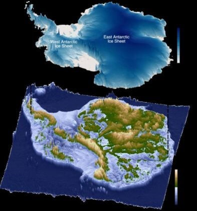
Buried beneath a 3,500 kilometer stretch of East Antarctic ice sheet lies a hidden landscape that once hosted flowing rivers. Aand these ancient waterways now control how ice moves toward the ocean.
Scientists using radar measurements have discovered extensive flat surfaces created by rivers that flowed across Antarctica roughly 80 million years ago, before ice covered the continent.
The finding reveals how geological processes from deep time continue shaping modern ice dynamics, with implications for predicting future sea level rise. East Antarctica contains enough ice to raise global sea levels by 52 meters if completely melted, making understanding its behavior critical for climate projections.
Radar Reveals Hidden Rivers
Durham University researchers examined radar data from multiple Antarctic surveys, discovering 31 distinct flat surfaces spanning 40% of East Antarctica’s coastline. These remarkably preserved landscapes show the characteristic signatures of river erosion: gentle slopes toward the coast, consistent elevations, and patterns that cut across underlying rock structures.
“The landscape hidden beneath the East Antarctic Ice Sheet is one of the most mysterious not just on Earth, but on any terrestrial planet in the solar system,” explains Dr. Guy Paxman, the study’s lead author and a Royal Society University Research Fellow at Durham University.
When researchers adjusted surface elevations to account for ice removal, the ancient riverbeds clustered at 200-450 meters above current sea level—exactly where coastal plains would form as rivers carved down to ocean level during Antarctica’s ice-free past.
From Gondwana to Ice Age
These river systems developed after East Antarctica and Australia separated approximately 80 million years ago, creating new coastlines and base levels for water flow. Before continental breakup, massive rivers flowed from central Antarctica all the way to northwestern Australia, creating connected waterway networks across the ancient supercontinent Gondwana.
The newly mapped surfaces preserve evidence of this transformation:
- Timing: Formed between continental separation (~80 million years ago) and ice sheet formation (~34 million years ago)
- Scale: Individual surfaces range from 200 to 50,000 square kilometers
- Preservation: Maintained their basic structure for over 30 million years under ice
- Modern influence: Direct ice flow into deep channels while supporting slow-moving ice above
Ice Highways and Speed Limits
Today’s ice flow patterns follow this ancient template with remarkable precision. Fast-moving glaciers—including major outlets like Totten, Mertz, and Denman—flow through deep troughs carved between the preserved river surfaces. Meanwhile, ice above the flat surfaces moves much more slowly, typically under 100 meters per year.
Professor Neil Ross from Newcastle University, a study co-author, notes the significance: “We’ve long been intrigued and puzzled about fragments of evidence for ‘flat’ landscapes beneath the Antarctic ice sheets. This study brings the jigsaw pieces of data together, to reveal the big picture.”
The ancient surfaces act as natural barriers to ice flow, potentially regulating current rates of ice loss. This suggests that geological inheritance from the distant past may be providing some stability to parts of East Antarctica, even as climate change accelerates ice loss elsewhere.
Future Ice Behavior
Understanding these buried landscapes could improve predictions of how East Antarctica will respond to continued warming. The flat surfaces may serve as stabilizing “pinning points” during ice retreat—areas where ice remains grounded even as surrounding regions experience thinning.
As ice margins retreat and thin, these elevated surfaces could form ice rises that buttress inland ice and slow mass loss to the ocean. However, current ice sheet models may not fully capture these effects, potentially affecting the accuracy of sea level projections.
The research team emphasizes the need for direct sampling of these surfaces through ice drilling to determine when they were last ice-free. Such information would help calibrate models for how this crucial region might behave as oceans and atmosphere continue warming.
The discovery demonstrates how Earth’s deep history continues influencing its present—ancient rivers that ceased flowing tens of millions of years ago still shape the movement of ice that could determine humanity’s coastal future. In Antarctica’s frozen archive, the past remains surprisingly active in governing what comes next.
ScienceBlog.com has no paywalls, no sponsored content, and no agenda beyond getting the science right. Every story here is written to inform, not to impress an advertiser or push a point of view.
Good science journalism takes time — reading the papers, checking the claims, finding researchers who can put findings in context. We do that work because we think it matters.
If you find this site useful, consider supporting it with a donation. Even a few dollars a month helps keep the coverage independent and free for everyone.