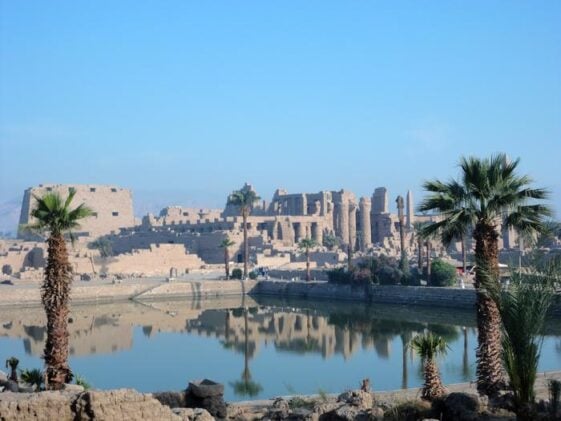
Egypt’s Karnak Temple, a sprawling monument that welcomes millions of tourists annually, began its existence on something far more humble: a patch of high ground surrounded by rushing water, possibly chosen for reasons that had nothing to do with strategic advantage and everything to do with matching an ancient creation story.
A comprehensive geoarchaeological survey has mapped the temple’s origins with unprecedented detail, drilling 61 sediment cores through the site to reconstruct how the Nile’s channels carved out the land beneath one of antiquity’s largest religious complexes. The findings, published today in the journal Antiquity, reveal that Karnak likely emerged during Egypt’s Old Kingdom period, centuries earlier than some scholars suspected, and that its location on an island configuration may have been deliberately chosen to mirror the “primeval mound” of Egyptian cosmology.
“This new research provides unprecedented detail on the evolution of Karnak Temple, from a small island to one of the defining institutions of Ancient Egypt,” says Dr. Ben Pennington, lead author and visiting fellow in geoarchaeology at the University of Southampton.
When Rivers Carved Sacred Ground
The research team, led by Dr. Angus Graham of Uppsala University, extracted sediment cores averaging more than six meters deep from within and around the temple complex, analyzing tens of thousands of ceramic fragments to date their findings. What emerged was a geological biography: before roughly 2520 BCE, the site would have been regularly submerged by fast-flowing Nile water, making permanent settlement impossible. Only after the river incised channels to the east and west, creating an elevated terrace segment, could occupation begin.
The earliest ceramic fragments found date between 2305 and 1980 BCE, corroborating the geological timeline and suggesting Karnak’s origins lie in the Old Kingdom rather than the First Intermediate Period, as many archaeologists had assumed. The debate over Karnak’s age has simmered for decades, with some researchers even proposing Predynastic occupation based on scattered artifacts. This survey appears to settle the question, at least for now.
The age of Karnak Temple has been hotly contested in archaeological circles, but our new evidence places a temporal constraint on its earliest occupation and construction.
The survey also revealed a surprise about the site’s hydrology. An eastern channel, previously little more than scholarly speculation, turned out to be more substantial than the western channel archaeologists had focused on for years. This eastern branch of the Nile, active during the First Intermediate Period and Middle Kingdom, measured between 220 and 500 meters wide during the Third Intermediate Period, suggesting it was a major waterway throughout much of Karnak’s early history.
Creation Myth Meets Geology
The most tantalizing aspect of the research concerns why ancient Thebans chose this particular spot. The elevated terrace surrounded by water channels would have formed an island of roughly 10 hectares, the only such configuration of high ground encircled by permanent watercourses identified in the Theban area. This matches descriptions from Old Kingdom Pyramid Texts, which describe the creator god manifesting as high ground emerging from “the lake.”
The fit seems almost too perfect to be coincidental. During the early Middle Kingdom, when annual floods arrived, the island would have appeared to rise from the receding waters as the inundation subsided, recreating the cosmological scene of the primeval mound emerging from the Waters of Chaos. The researchers note that surrounding land one meter lower than the terrace top would have been submerged during floods, then revealed as waters fell, potentially doubling the island’s visible area and completing the illusion of upward movement.
Whether Theban elites deliberately selected the site to embody their creation mythology remains uncertain. Pragmatic factors, like the location’s proximity to Old Kingdom activity centers across the river at at-Tarif, may have mattered just as much. Still, the geological configuration foretells the more developed cosmology of later periods, when Middle Kingdom texts explicitly describe the primeval mound rising from Nun, the Waters of Chaos.
The survey also documents how Karnak’s inhabitants responded to their shifting landscape over three millennia of occupation. As western channels gradually silted up, temple construction expanded westward, with massive pylons (monumental gateways) built atop former riverbeds. In at least one instance, desert sand was deliberately dumped into a channel south of what would become the Hypostyle Hall, apparently to create new building land at the start of the New Kingdom around 1540 BCE.
The river channels surrounding the site shaped how the temple could develop and where, with new construction taking place on top of old rivers as they silted up.
Co-author Dominic Barker from Southampton notes that ancient Egyptians also actively shaped their environment: “We see how Ancient Egyptians shaped the river itself, through the dumping of sands from the desert into channels, possibly to provide new land for building.”
The eastern channel finally silted up during or after the Macedonian-Ptolemaic period, with a residual waterway, possibly a maintained canal, persisting until around 470 CE. By then, Karnak had stood for nearly three thousand years, its foundations literally built on the sacred geography its builders may have sought from the beginning.
The research team, operating under permit from Egypt’s Ministry of Tourism and Antiquities, plans to extend their geoarchaeological work to other major sites in the Luxor region, aiming to understand the broader landscape of ancient Egypt’s religious capital. For now, the sediment cores have spoken: Karnak rose from very specific geological circumstances, and whether by design or fortune, those circumstances happened to match the most fundamental story its builders told about how the world began.
Antiquity: 10.15184/aqy.2025.10185
ScienceBlog.com has no paywalls, no sponsored content, and no agenda beyond getting the science right. Every story here is written to inform, not to impress an advertiser or push a point of view.
Good science journalism takes time — reading the papers, checking the claims, finding researchers who can put findings in context. We do that work because we think it matters.
If you find this site useful, consider supporting it with a donation. Even a few dollars a month helps keep the coverage independent and free for everyone.